Tiverton means “tavern town.” You were allowed to have a tavern at a crossroads, and Tiverton had a crossroads. Today we call this crossroads “Tiverton Four Corners.” Four Corners is a nice neighborhood, with old houses and shops. A stream (Borden Brook) runs through the line of shops; perhaps the stream once powered a mill.
Just east of Four Corners (on East Road, also known as Route 179) is Weetamoo Woods, which has some seven miles of trails, and merges with Pardon Gray Preserve, which has another two miles of trails. You can think of Weetamoo/Gray as a large rectangle, extending north from Route 179, bounded on the west by Main Road (Route 77), bounded on the east by Lake Road, and bounded on the north by Lafayette Road (the eastern part of Lafayette Road is a dirt road, closed to cars). Weetamoo/Gray can be accessed on any of its four sides, but I usually park at the lot on Route 179.
Weetamoo is owned by the town of Tiverton, while Gray is owned by the Tiverton Land Trust. Weetamoo/Gray is an “oak-holly forest,” like you find in Little Compton. Weetamoo/Gray also has a cedar swamp.
Below is an 8-mile route at Weetamoo Woods. Shorter routes are possible (see map here; maps are also available at the property and at AllTrails).
The trail heads north from Route 179, following an old colonial road. As Ken Weber says in More Walks and Rambles in Rhode Island, “The trail begins on what was Eight Rod Way, a road begun in 1679 as a link between Sakonnet Point and Plymouth Colony.... The ambitious project was never completed, but here you can see just how impressive a road eight rods, or 132 feet, wide would be.”
There’s a road in North Kingstown, Rhode Island called “Ten Rod Road.” The colonists used wide roads to drive herds of livestock; as Wikipedia says, “Drovers’ roads are often wider than other roads, able to accommodate large herds or flocks.” There are several streams in Weetamoo/Gray, with charming stone-work creating bridges, mill-races, etc. There are also some old foundations (house sites).
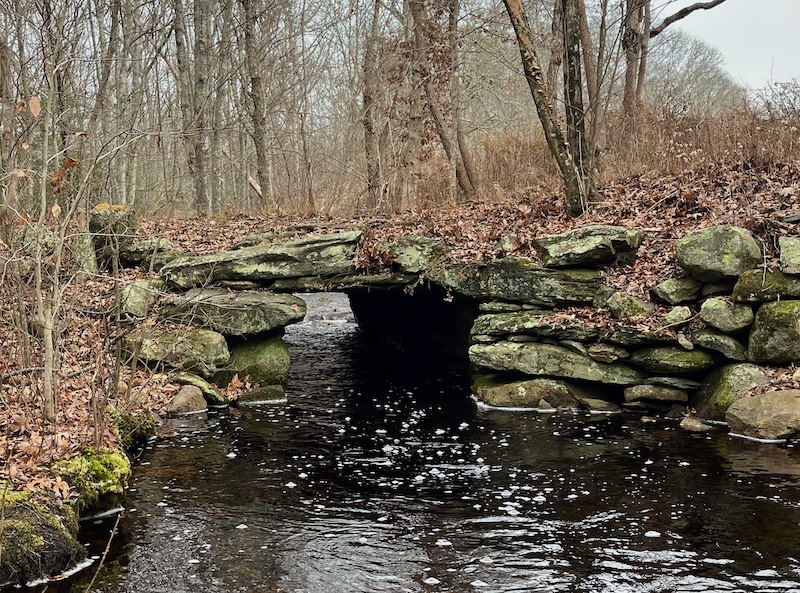
The bridges in Weetamoo are of two kinds, slab and arch. Below is a slab bridge (I marked its location with an orange pin).
Below is one of Weetamoo’s arch bridges (I marked its location with a blue pin):
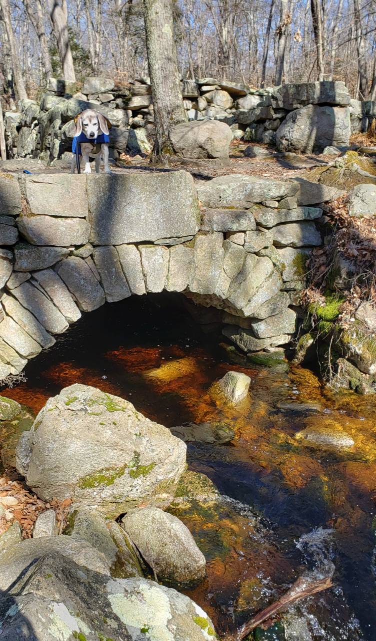
This arch-style bridge was built without cement.
It’s part of the old mill.
I marked the location of High Rock with a black pin, and Wildcat Rock with a red pin. I put a yellow pin on a ridge/hill that affords a view of the Sakonnet River (not a good view, and only if the leaves are off the trees). I put a green pin on a large oak tree, probably the tree called “Border Oak.”
There are NativeAmerican stone structures in Weetamoo. Below is what might be called a Dolmen (comparable to the Dolmens in Foxboro and Parker Woodland). Since Dolmens are usually closer to the ground, this one might be called a Raised Dolmen. I marked its location with a grey pin.
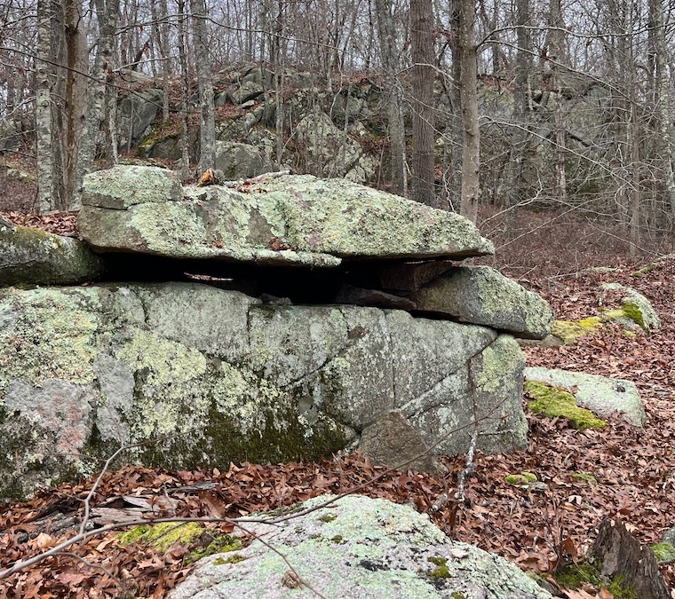
Below is a large overhanging rock that seems to be held in position by smaller propping rocks. Did the Native Americans create the overhang? Did they want to make a space that was protected from the elements? I marked this spot with a brown pin.
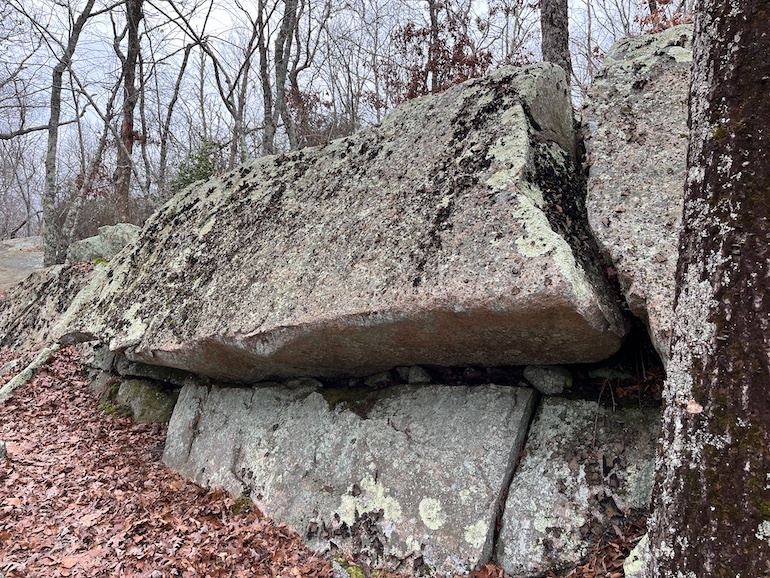
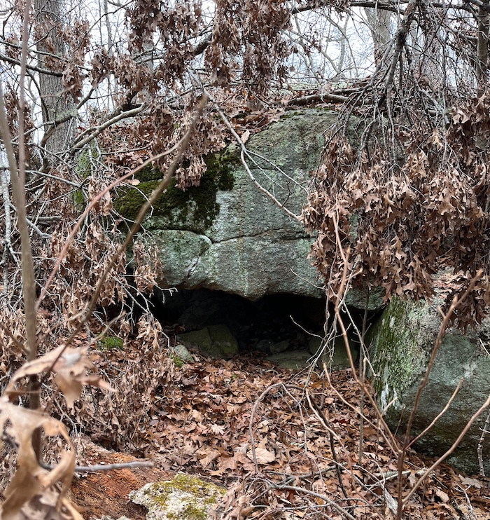
Below is another large rock that seems to have been propped by Native Americans. This one doesn’t create an overhang, it creates a sort of cave, a space under the propped rock. I marked the location with a star icon.
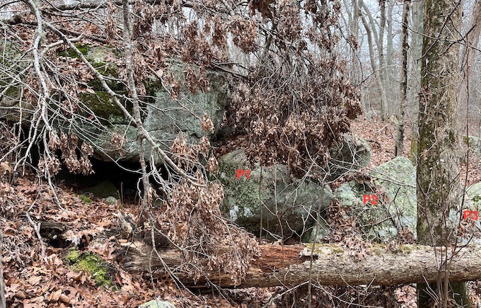
Below is the same cave, showing how it was created, how the big stone was propped-up. I put a red “P1” on the propping rock; P2 props or stabilizes P1, and P3 seems to stabilize P2. (I mentioned a similar “propping chain” in my Seekonk notes.)
One of my favorite spots in Tiverton is the Emilie Ruecker Refuge. Ruecker is a series of small hills (drumlins?), surrounded by salt marshes and the Sakonnet River. Lots of oak trees, and an occasional osprey. In Walks and Rambles in Rhode Island, Ken Weber calls Ruecker “a little jewel.”
From Ruecker, you can drive south to Fogland Beach; this is one of the most charming drives in Rhode Island, with farms, stone walls, and water views.
Ruecker is owned by Audubon. Another Audubon refuge with short trails and salt marshes is the Touisset Marsh Refuge in Warren. Touisset Marsh is about eight miles north of Ruecker. As Ruecker is on the east side of the Sakonnet River, so Touisset is on the east side of the Kickemuit River. You might see hawks patrolling Touisset’s fields.
Two or three miles north of Ruecker, on Highland Road, is Fort Barton, a RevolutionaryWar fort with earthworks. There’s a short, paved trail to a tower; the tower offers a good view of the Sakonnet River, Aquidneck Island, Island Park, Mt. Hope Bridge, etc. Behind the tower are several miles of trails.
Below is a 2.5-mile trail that starts at Fort Barton. It crosses Archer Brook, then Sin & Flesh Brook. The terrain is up-and-down, cliff-and-valley. I think there are some erratic boulders, indicating glacial action. During the first 3/4 mile, there are lots of oak and holly, but later you’ll see lots of laurel. After rain or snow-melt, the trail can be muddy, so waterproof shoes might be needed.
Near the Ruecker Refuge is the Pocasset Ridge Conservation Area. Below is a 3-mile route at Pocasset Ridge.
Pocasset Ridge has a high cliff from which you can see Mt. Hope Bridge (I marked the cliff with a blue pin). The view from the cliff isn’t a great view, the view from Fort Barton is better. If you’re interested in NativeAmerican stone structures, I marked a propped boulder with a green pin, and possible propped boulders with purple and black pins.
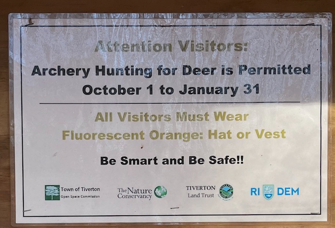
While hiking at Pocasset Ridge, I encountered a hunter with a crossbow. Here’s some information on hunting at Pocasset Ridge:
The beginning of the PocassetRidge trail is muddy after a rain. There’s some grass on the trail, so ticks could be a problem.