The best website on Smithfield trails is Seven Scenic Walks in Smithfield, created by the Smithfield Conservation Commission, and written by Ken Weber (Weber wrote Weekend Walks in Rhode Island, and other books). More information on Smithfield walks can be found at Trails & Walks in Rhode Island.
Mowry
Mowry Conservation Area is a favorite of mine. It’s on the west side of Old Forge Road, you can park along the road. You’ll soon see the Woonasquatucket River flowing under an overhanging rock, a charming bridge, and the remains of old mills (one mill was 100-200 yards north of the bridge, another was 100-200 yards south of the bridge). The rock hangs far over the water, doubtless because the water has worn away the lower rock.
If you examine the little cliff near the river (the cliff is about 100 yards north of the bridge), you’ll notice it’s not only smoothed by the glacier, it’s also scooped and grooved. If you cross the road later, and walk to Stump Pond, you’ll find that the cliff at the edge of the pond is also smoothed, scooped, and grooved.
Cross the bridge to reach the trail. The trail is about one mile, and it’s quite steep. Lots of large outcrops. Many of the outcrops are foliated. What kind of rock is this? Schist? (The word “foliated” comes from folium meaning “leaf,” as in the leaves of a book. The word “schist” comes from the Greek word for “split,” since this kind of rock splits easily.)
Below is a 1-mile walk at Mowry, then an additional mile on the east side of Old Forge Road.
I believe there are two standing stones in the eastern section. Standing stones were set up by Native Americans. They’re generally higher in the center, sloping down at the sides, like the head and shoulders of a person. Below is a photo of a standing stone near Stump Pond (on my map, I marked the location of this stone with a pin).
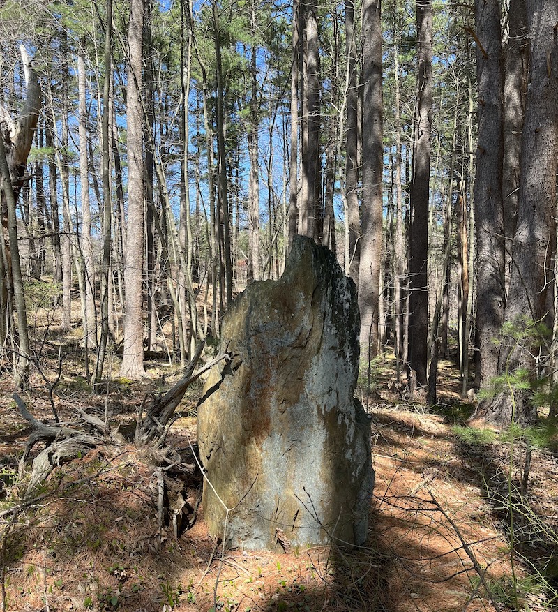
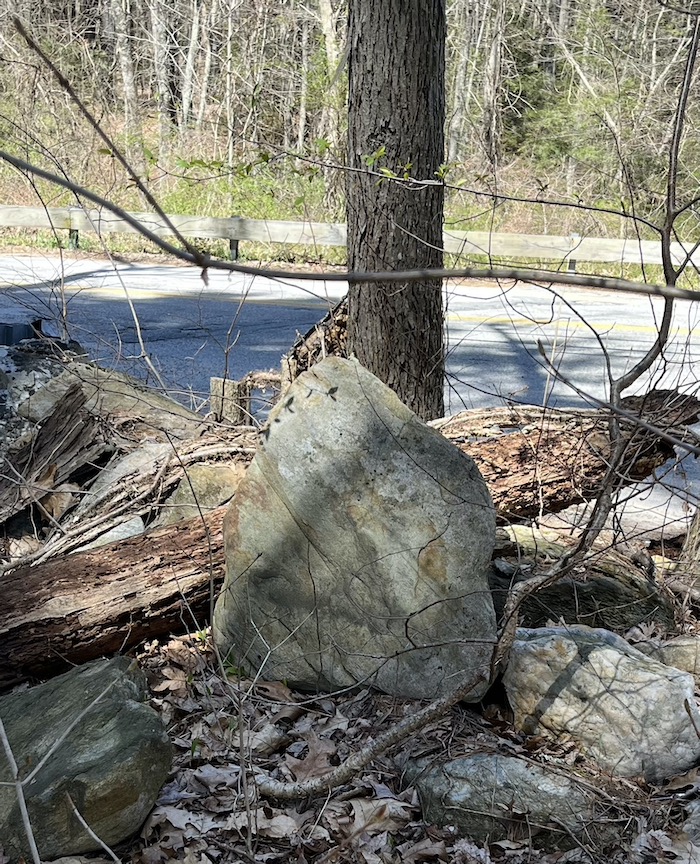
The above stone is massive — 6 feet tall, and probably weighing thousands of pounds. Below is a smaller standing stone near Old Forge Road. This smaller stone is placed rather than embedded; it leans against other stones.
Since Native Americans had a special feeling for water, perhaps it’s not surprising that these standing stones were placed near the river (but far enough from the river to be unaffected by a flood). Below is Daniel Boudillion’s photo of a standing stone in Boxborough, Massachusetts; Boudillion is an expert on Indian stone structures.
Boudillion calls a stone with this shape a “manitou stone.”
The eastern section has a view of Stump Pond, and an uphill trail to a farming area called Revive the Roots (also known as Mowry Commons). The old Mowry home can be seen in this farming area, and some smaller buildings, one of which is a geodesic dome.
More on Indian stones
Solstice Stones, Boxborough MA
Estabrook Woods, Concord MA
Great Brook, Carlisle MA
Beebe Woods, Falmouth MA
Maudslay State Park, Newburyport MA
Standing Stones, Smithfield RI
Queen’s Fort, Exeter RI
Connors Farm
Connors Farm is a short, steep walk, with striking cliffs, erratic boulders, a stream, a pond, and a wild cranberry bog. Connors Farm is on the west side of Smithfield, not far from Glocester. You can shorten the trail by following the green markers, or you can lengthen the trail by following the yellow trail, also known as Jim Russell Preserve. The route below follows the red markers, and is about 1.5 miles.
The cliffs at Connors reminded me of the SnakeDen cliffs, though they aren’t quite as big as the SnakeDen cliffs. Were the Connors cliffs and the SnakeDen cliffs created at the same time, by the same geological forces? And could those forces have also created Purgatory Chasm in Sutton, Massachusetts? Connors is north of Snake Den (slightly west of north), and Purgatory Chasm is north of Connors (slightly west of north).
Stillwater Scenic Trail
Stillwater goes along the Woonasquatucket River. Here’s a 3-mile walk (3 miles round-trip) at Stillwater.
The river is intermittently dammed to create ponds; Smithfield is sprinkled with these ponds. The Stillwater trail is flat, smooth, and largely bare of vegetation, so the tick risk is slight. There are small parking lots for the trail on Farnum Pike (Route 104) and on Capron Road. I suggest parking on Farnum Pike, so it’s easier to follow Ken Weber’s Stillwater notes.
The above route uses the parking lot on the east side of Farnum Pike. It also crosses Farnum Pike, and takes a short trail to Stump Pond (also called Stillwater Reservoir). There are some short trails at various points around Stump Pond; see AllTrails for more info.
Smith-Appleby House
Near Stillwater is the Smith-Appleby House, which dates to 1696, and is the home of the Smithfield Historical Society. Below is the Smith-Appleby House as it appeared in mid-April. This is the north side of the house, the back of the house, though it faces the parking area.
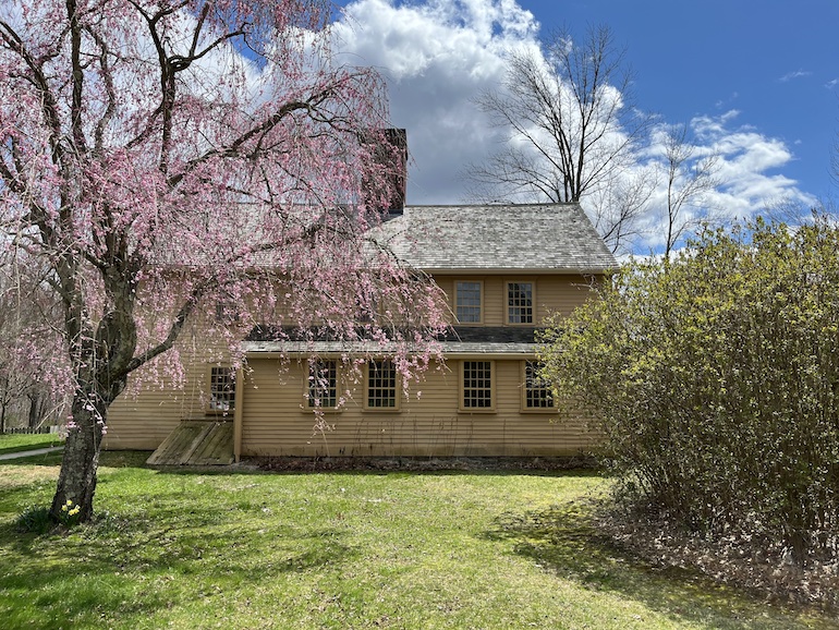
Note the 12-over-8 window-panes (12-over-12 is more common). The oldest part of the house was built by Elisha Smith, grandson of John Smith, one of the original founders of Providence. The house has nice views/landscaping, and a historic barn. The house overlooks the Woonasquatucket River and Georgiaville Pond.
Wikipedia says that the town of Smithfield is named after the London district of Smithfield, not after the Smith family, but other sources tell a different story. Smithfield separated from Providence in 1731, and North Smithfield separated from Smithfield in 1871.
Ken Weber Conservation Area at Cascade Brook
This trail is for the young and agile, it has some difficult sections. There are many outcrops, and some rather large cliffs. Some outcrops are smoothed and grooved by glaciers. You’ll see some erratic boulders, too.
One of the highlights of the trail is a small brook and a cascade (might be dry in mid-summer). Below is a 1-mile route.
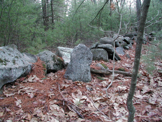
Near the start, I put a pin on a crescent-shaped rock pile (it’s on your right as you’re heading away from the parking area). This rock pile must be Indian; nature doesn’t make such things, and neither did white settlers. (Click here for a video about a crescent-shaped cairn in Concord, Massachusetts.)

Crescent rock pile
I put another pin about halfway through the walk, at the location of a small standing stone. This stone is near an old chimney, probably the location of a house. Why a house would be built on a ledge, I can’t explain. Since the standing stone is near the chimney/house, and since it doesn’t have a “manitou shape,” I think it’s probably the work of a white settler, perhaps a gravestone.
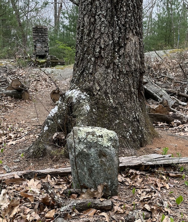
Small standing stone
In back left is an old chimney