Exeter, Rhode Island
Queen’s Fort is in the northeastern corner of Exeter, near North Kingstown and near Route 4. A visit to Queen’s Fort could be combined with a visit to Wickford Village, or combined with a visit to Fisherville Brook Wildlife Refuge.
Queen’s Fort is rather small, and the terrain is rocky, so you may not enjoy it unless you’re interested in Indian stone structures or erratic boulders. Queen’s Fort is chock full of erratics; only Beaver River has as many erratics. I didn’t see a parking area at Queen’s Fort, but parking along Stony Lane seems easy. Queen’s Fort is a hill; when the leaves have fallen, you can see the hill looming above you from Stony Lane.
Queen’s Fort is named after an Indian chief, Queen Quaiapen. Quaiapen died in 1676, a casualty of King Philip’s War. Wikipedia says that Queen’s Fort was built in 1676, the second year of King Philip’s War. In my view, this is a gross error; it was neither a fort nor built in 1676.
I believe Queen’s Fort was a special place for the Indians, not a fort. It was special (or sacred) because of its elevated position, and its unusual mass of boulders. I would guess it was built before King Philip’s War, but it’s difficult to date Indian stone structures. My view of Queen’s Fort was shaped by the book Manitou, an important work on Indian stone structures in New England. (Click here for my discussion of an Indian structure in Massachusetts.)
The authors of Manitou, Byron Dix and James Mavor, mention two stone enclosures at Queen’s Fort.1 On the map below, I marked the larger enclosure with a yellow pin, the smaller with a purple pin.

Larger enclosure, with spiral shape
Dix and Mavor say that if you’re in the smaller enclosure (the northeastern enclosure), the larger enclosure is to the southwest, and aligns with the setting sun at the winter solstice. I find their reasoning persuasive. They write, “Winter solstice alignments are the most frequent in our experience with New England stonework, not surprising because the winter solstice was the most important Algonquin Indian festival, the Feast of Dreams.”
You’ll notice that the map shows two walks, both of which start from Stony Lane. The western walk follows a trail, and takes you to the large, spiral enclosure, which has a diameter of about 10 feet; this large enclosure is at the summit of the hill. The eastern walk isn’t on a trail; it’s rougher and steeper than the western walk, but it enables you to reach the smaller enclosure, which has a diameter of about 5 feet (if you tried to go directly from the larger enclosure to the smaller, your route would be obstructed by numerous boulders).

Boulders abound at Queen’s Fort. Many are covered with lichen.
According to Dix and Mavor, both enclosures are built into stone rows. “In the northeast row is a partial enclosure, which could be described as a bastion if the structure were a fort.” I found this “partial enclosure” without difficulty. Just south of the partial enclosure, and “several feet lower,” is a “circular enclosure.” I found the circular enclosure, too.
It’s difficult to see the southwestern enclosure from the northeastern enclosure, even if the leaves are down. You may want to attach a brightly-colored shirt to something in the southwestern enclosure, or ask a friend to stand in the southwestern enclosure. An app called Sun Seeker will show you the location of the sun on the winter solstice. Sun Seeker agrees with the arguments of Mavor and Dix: the two enclosures align with the winter solstice.
Update 2024
I visited Queen’s Fort again, and discovered a “Northeast Passage” from the big enclosure to the small enclosure (map below). I followed a stone row that begins south of the big enclosure, connects to the big enclosure, and then arcs toward the small enclosure.
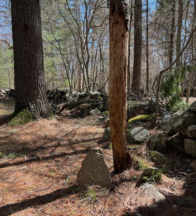
Between the two enclosures is a gap in the stone row, and in the center of the gap is a short standing stone (the row, the gap, and the standing stone are all mentioned in Manitou). Below is a picture of (what I believe to be) the standing stone mentioned in Manitou. I marked its location with a blue pin (on my second map).

I marked the location of the big enclosure with a yellow pin (on the second map). I marked the east end of the stone row with a black pin. As I mentioned above, this east end has a partial enclosure and a circular enclosure — both utterly unsuitable for defensive purposes.
By following the route on the second map, you can make one hike, instead of the “double hike” in my previous map. This one hike is only about 1/4 mile (1/2 mile round-trip).
Below is a picture of the stone row, curving toward the small enclosure. There are numerous manitou stones (upward-pointing stones) in and around this row.

More info about Queen’s Fort at this page, which says that the spiral enclosure was rebuilt around 1980, and the spiral shape dates to that time; before 1980, it was probably a circular enclosure.
More on Indian stones
Solstice Stones, Boxborough MA
Estabrook Woods, Concord MA
Great Brook, Carlisle MA
Beebe Woods, Falmouth MA
Maudslay State Park, Newburyport MA
Standing Stones, Smithfield RI
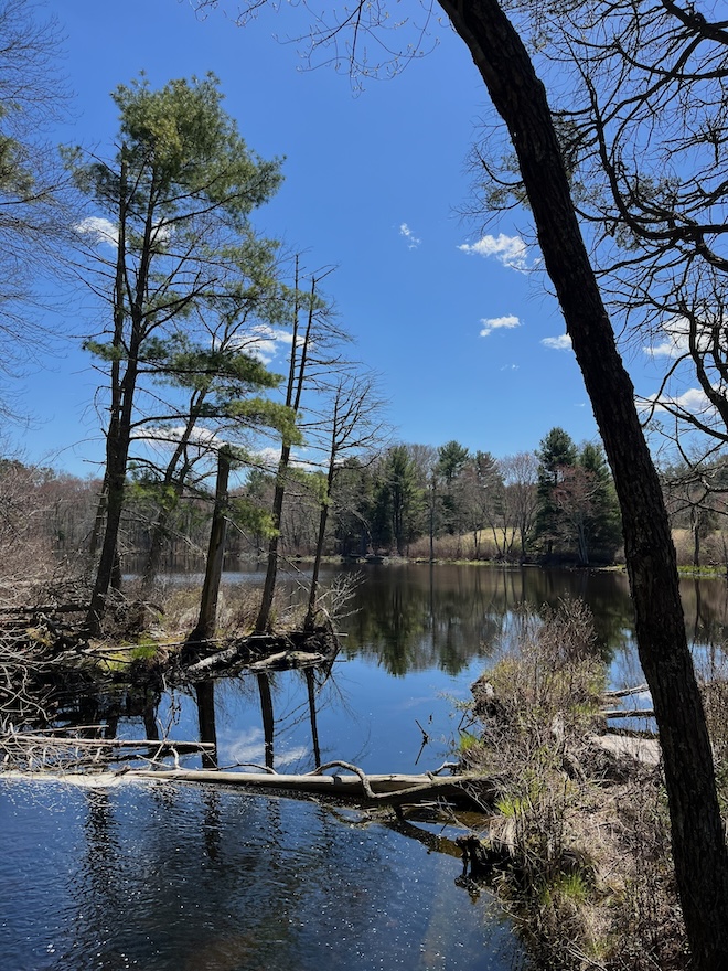
Fisherville Brook is an Audubon refuge in Exeter RI. It has 1,000 acres, a charming pond, and miles of trails. Below is a 4-mile trail that makes two loops — one north of the road, and one south. The southern loop is more scenic; it has a pond and meadows (I put a red pin on a scenic spot overlooking the pond). The southern loop is described in Ken Weber’s book, More Walks and Rambles in Rhode Island.
Below is the pond at Fisherville.
There’s NativeAmerican stone-work at Fisherville, especially in the northern section. Below is an example.

The Fisherville website mentions a “lovely historic cemetery.” This probably refers to the cemetery that’s near the pond (west of the pond). There’s another cemetery north of the road (close to the road), but it has no visible gravestones. (The cemetery website says there are two unmarked “fieldstones.”)
Below is what I would call a manitou stone. To the right of this stone is a smaller vertical stone. Are these the two stones that the cemetery website calls “unmarked fieldstones”?