Here’s a 5-mile section of the Narragansett Trail:
I learned about this route from Ken Weber’s Walks and Rambles in Rhode Island, though most of it is actually in Connecticut. The whole Narragansett Trail is 25-30 miles (about 60% is in Connecticut, 40% in Rhode Island).
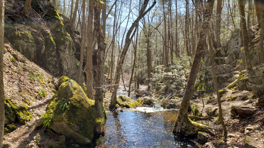
Weber says that the highlight of the 5-mile route is a “magnificent ravine.” The ravine is even more scenic than I expected; it’s especially scenic after a rain, when the Green Fall River is racing through it. I recommend visiting after a moderate amount of rain. If you go after lots of rain, the trail might be soggy, the streams might be dangerous to cross, and the ledges might be slippery. Here’s a picture of the ravine:
The route on my map begins at the boundary that divides Rhode Island and Connecticut. The parking area is on the right side (north side) of the road, it’s big enough for perhaps three cars. The road is a dirt road, quite solid and driveable, even after prolonged rain. There’s a trail directly in front of the parking area. Ignore that trail, the real trail starts a few feet further west (further along the road), there are signs marking it.
This is the Narragansett Trail, it goes to the right (north). You’ll see yellow blazes, light-blue blazes, and dark-blue blazes. The Narragansett Trail is marked with light-blue blazes, the Tippecansett Trail is marked with yellow blazes, the Freeman Trail with dark-blue blazes.
Walk north, along the state line, for 10-15 minutes. You’ll see mountain laurel and erratic boulders (Weber speaks of “laurel thickets that remain green all year and blossom spectacularly in June”). On my map, I put a “C” on some interesting cliffs. Google Maps calls the cliffs “Dinosaur Caves,” but there seem to be neither dinosaurs nor caves. The trail loops at this point; for a better view of the cliffs, take the loop; if you want a more direct route, you can skip the loop. On Google Maps, “Dinosaur Caves” is slightly south of my loop, perhaps I should have descended from the cliff top to the cliff bottom a bit sooner.
Below is a cliff with a projecting rock, a “diving board” rock, similar to the ParkerWoodland diving-board.
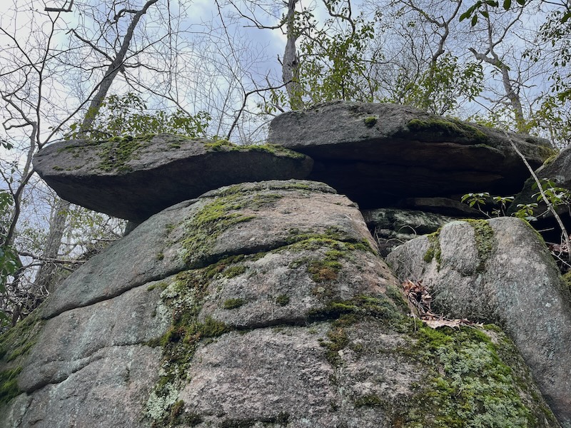
This projecting rock has been manipulated/propped; it’s fatter than the ParkerWoodland diving-board. (I’m referring to the rock on the left of the picture, but the rock on the right may have also been manipulated/propped.) NativeAmerican art is about putting rocks into the air, and this rock is in the air. I marked the location with a blue pin.
After you’ve passed “Dinosaur Caves,” after you’ve walked 10-15 minutes from the parking area, the Narragansett Trail turns left (west), and heads into Connecticut, the other two trails turn right (east). I suggest you turn left, and follow the Narragansett Trail. (If you turn right, you’ll come to a broad ledge of bare rock. Weber calls it “one of the larger stone ridges,” and Weber says it’s “considered the southern terminus of the Tippecansett Trail.” On my map, I put an “L” on this ledge. John Kostrzewa writes in the Providence Journal that “Tippecansett” means “great clearing.” Could this broad ledge be the great clearing? Is that why it’s the terminus/destination of the trail? From the clearing, the yellow trail heads north to Beach Pond, and the dark-blue trail heads south to Yawgoog Pond.)
The beginning of this 5-mile trail is in the Yawgoog Scout Reservation, the latter part of the trail is in the Pachaug State Forest. The last 20% of the trail is on dirt roads that lead back to the parking area.
I put a “D” on a detour that’s just before a stream. The detour is mentioned by Weber, and appears on AllTrails. The detour goes north about 1/6 mile; it ends at a large rock, which would require climbing. As you walk north on the detour, a marshy pond is on your left.
When you finish the detour (or if you skip it), cross the stream on a wooden bridge, then scramble up the steep outcrop. About 50-75 yards to the right is a large rectangular boulder, both ends of which are off the ground (picture below).
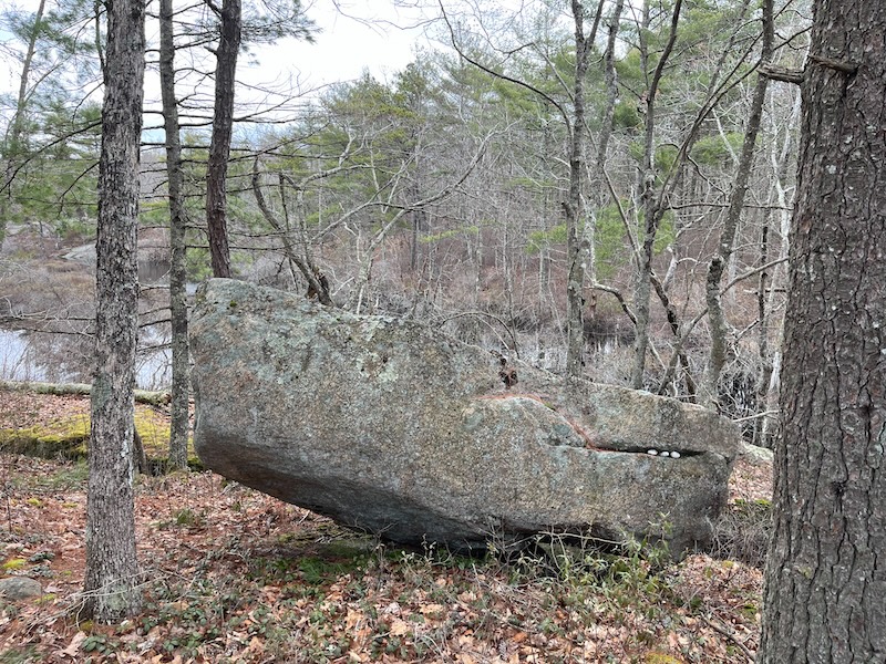
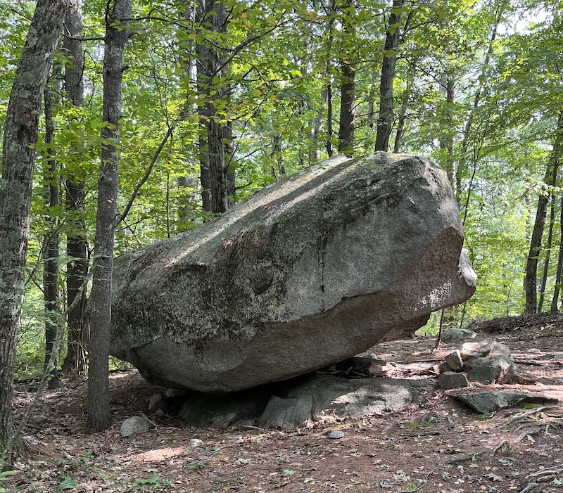
In general, nature puts boulders in the earth, Native Americans put boulders in the air. I think the above boulder was manipulated by Native Americans; I marked its location with a yellow pin. It has been propped up on a ledge without the use of propping stones. I saw this technique used in Foxboro (picture below).
Below is another erratic boulder along the Narragansett Trail; it, too, seems to have been propped on a ledge, perhaps without the use of propping stones; I marked its location with a purple pin.

Continuing along the trail, you’ll soon see a stone niche on the left side of the trail; I marked the location “N”.

Niche
I put an “M” at a mill site, a charming stream/cascade that has the remains of an old mill. The mill race is a stone tunnel. (A mill race is a secondary stream, built by the mill-owner. It allows for a controlled flow of water, a flow with the direction and force needed by the mill.) Here’s a picture of the cascade:

The trail continues toward the upper-right of this picture, it doesn’t cross the stream here. The stream is on the left of this picture, the mill race (the downstream end of the mill race) is in the upper-right. Ken Weber describes the mill race as “a long, stone-lined tunnel.” The trail continues for perhaps 50 yards from the spot of this picture, then meets the stream again, and crosses it. Near this crossing is the start of the stone-lined tunnel (the upstream end of the tunnel). After heavy rain, this might be a difficult crossing.
After you cross the stream, you’ll come to an opening in the woods. A short, dead-end trail on the right leads to a lean-to that’s used by campers; make sure you follow the light blue blazes of the Narragansett Trail. (The stream you just crossed is Peg Mill Brook; the lean-to is marked “Peg Mill Shelter” on Google Maps.)
I put an “O” at an option where you can take the BlueRed trail (as I did), or the BlueOrange trail, which goes closer to the water. A third option is to go south, along the eastern shore of the pond; this is the shortest option, it’s the one Weber describes in his book, and it’s the one I recommend.
If you follow the eastern shore of the pond, you’ll go through a pleasant pine forest — a stone wall on your left, pond on your right. When you get to the end of the pond, there’s a dam, and water tumbles over the dam, forming the stream. You can scramble down to stream-level, but I don’t recommend it; I recommend walking about 1/8 mile, until the trail descends gradually to stream-level.
I marked the “Sluice Cairn” with an “S”. A web-page says, “The cairn was apparently part of a sluice system that diverted water to a shingle mill in the late 19th century.”
I discuss another scenic section of the Narragansett Trail here. Click here for a 22-mile version of the Narragansett Trail, showing both the Connecticut section and the RhodeIsland section. As far as I can tell, the closed sections of the trail are still closed.
Click here for a 16-mile section of the Narragansett Trail; this section is entirely in Rhode Island. Instead of stopping at Stubtown Road, it continues south for another 6-7 miles. It finally stops at a spot that Google Maps calls “Canonchet Preserves” (near 730 Main Street, Hope Valley, RI; Main Street is a road with many names, it’s also known as Route 3 and Nooseneck Hill Road).
For more info on trails in southeastern Connecticut, visit the website of the Avalonia Land Conservancy.