Oak Hill, Littleton MA
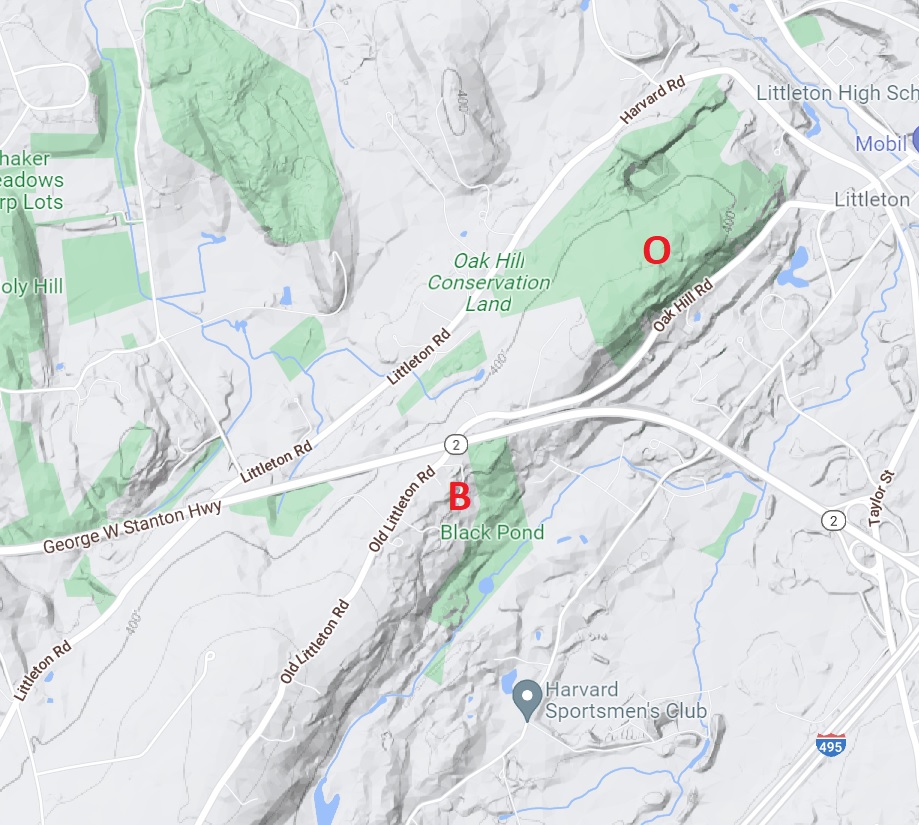
Tophet’s Chasm is within a refuge called Oak Hill. Tophet’s Chasm may be part of the same ridge-and-depression that makes up Black Pond, which is toward the southwest in Harvard MA. On the terrain map below, I marked Oak Hill “O” and Black Pond “B”
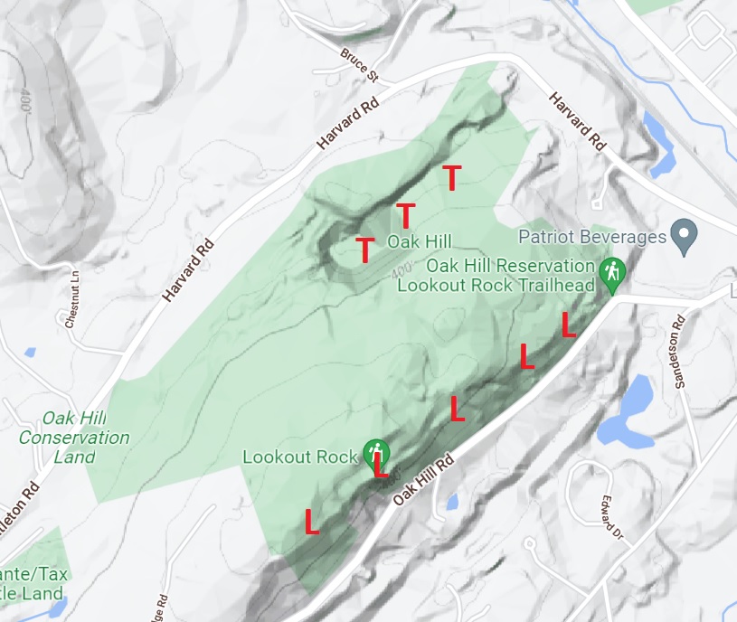
Instead of associating Black Pond with Tophet’s Chasm, perhaps we should associate Black Pond with a ledge on the southeast side of Oak Hill. On the map below, I marked Tophet’s Chasm with a T, and the ledge with an L. Lookout Rock is part of the ledge, the highest point of the ledge.
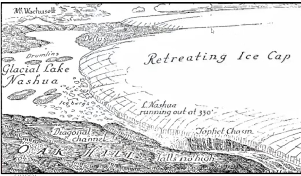
Perhaps we should regard Tophet’s Chasm as a separate land-form, created by a waterfall that wore away the bedrock (a “retreating waterfall”). Below is a drawing showing Tophet’s Chasm being created by a 120-foot waterfall; the waterfall is emptying a lake called “Lake Nashua,” which is being supplied with water by a melting glacier.
I find the waterfall theory plausible. But it doesn’t answer the question, Why did the water run out at this spot? Perhaps there was some cracking/settling/depression at this spot, and that depression drew the water here. Some geologists argue that Tophet’s Chasm was caused by a drop of the land, a “keystone fault.” So there are two competing theories — the retreating waterfall, and the keystone fault. Could both these agents have acted together? Could a fault/depression have drawn water/waterfall to this spot, and could the waterfall have deepened the depression?1
This website says, “Oak Hill is the northern tip of a long ridge of hills called Shrewsbury Ridge.” The ridge stretches from Oak Hill southwest to Shrewsbury.
Below is a map of the path through the bottom of Tophet’s Chasm.
The bottom of the chasm is likely to be wet, especially after rain. Would it be best to hike the bottom when the water is frozen, and you’re wearing spikes? Or would it be best to hike the bottom after a prolonged drought? In my view, trekking poles are useful on a hike like this.
You may want to visit Lookout Rock as well as Tophet’s Chasm; apparently trees were cut around Lookout Rock to create a view of Boston. Below is a route that goes to Lookout Rock and Tophet’s Chasm; it’s a 3-mile route. I wasn’t able to see Boston from Lookout Rock. Perhaps binoculars are needed?
A local historian named Daniel Boudillion argues that Tophet’s Chasm got its name from the Indian rituals performed in it, rituals that reminded early settlers of the screeching of devils, and the fires of Hell. Boudillion says that swamps were often called “Tophet” since Indian rituals were often performed in swamps.
I find no indication that Thoreau visited Tophet’s Chasm, though he would have been intrigued by its name, and he would have enjoyed seeing such an unusual land-form. The Chasm is about 13 miles northwest of Thoreau’s house in Concord, so it’s within his “walking range,” but just barely within.
There’s an esker to the southeast of Oak Hill Road, parallel with Oak Hill Road. I drew a black line to show the approximate location of this esker. You can see the esker in Google Maps if you go to “terrain view.” I’m not sure how to access this esker; I put a red pin on a possible access point.
| Footnotes | |
| 1. | In an earlier issue, I discussed the origin of Yosemite Valley. Did the bedrock crack and fall, creating Yosemite Valley? Or did water/ice carve the valley? I argued that both forces may have contributed.
The waterfall drawing comes from an article by Richard J. Lougee, printed in June 1956 in Appalachia. The article was entitled “Tophet Chasm, The Drainage Waterfall of Glacial Lake Nashua.” Click here for a Youtube video by William Vales on the geology of Tophet’s Chasm, and other nearby sites. The Keystone Fault theory was developed by William Otis Crosby and his son Irving Ballard Crosby. In 1925, the Crosbys published an article called “Keystone Faults” in the Bulletin of the Geological Society of America (Volume 36, Number 4, pages 623-640). The Crosbys pointed to Keystone Faults as the cause not only of Tophet’s Chasm, but also of Purgatory Chasm in Sutton MA, Purgatory Chasm in Great Barrington MA, Ice Glen in Stockbridge MA, and NewHampshire Notches, such as Dixville Notch, Crawford Notch, etc. Click here for my remarks on the chasms in Stockbridge and Great Barrington. Irving Crosby published a shorter piece on keystone faults in 1930. He distinguishes keystone faults from the ridge-and-ravine pattern (sometimes called “horst and graben”). back |