Below is a 6-mile route in the Pachaug State Forest. There are bears in the area, though I didn’t see any. I did see what looked like a fox, but may have been a coyote.
The highlight of the route is Mt. Misery, about halfway through the route (I followed the route in a clockwise direction). The summit of Mt. Misery has good views to the east and southeast, as well as good picnic spots. Below is the view from Mt. Misery. I marked the spot with a black pin.

Notice there are several dead trees in the above picture. I saw many dead trees on this walk, perhaps the result of gypsy moths, drought, wood-boring insects, and high winds. Many oaks are dying; in some areas, 90% of oaks died. All these dead trees are a fire hazard; sometimes rangers intentionally burn an area, to reduce fire risk.
You might notice raptors at the summit of Mt. Misery. Raptors seem fond of mountain-tops; or perhaps raptors are easier to spot from mountain-tops.
I parked near Lowden Brook, then went south along the blue-blazed Pachaug Trail, toward Mt. Misery. The trail is grassy, especially on the western side of my loop, so ticks could be a problem.
The eastern side of my loop is a segment of the Pachaug Trail, the western side is a segment of the Nehantic Trail, but remember to leave the Nehantic Trail at Trail 2 Road (I marked the spot with a red star; Trail 2 Road is called Lee Road on some maps); at this point, you’ll start going east to return to your starting point.
Both the Pachaug and the Nehantic Trails are Blue-Blazed Trails. The two trails meet about 1.4 miles before the summit of Mt. Misery (I marked the spot with a blue hiker icon), then separate about .4 miles (4/10 miles) after the summit (I marked the spot with a red pin); at both these junctions, you turn right (if you follow my route clockwise). The major trails in Connecticut are the Blue-Blazed Trails.
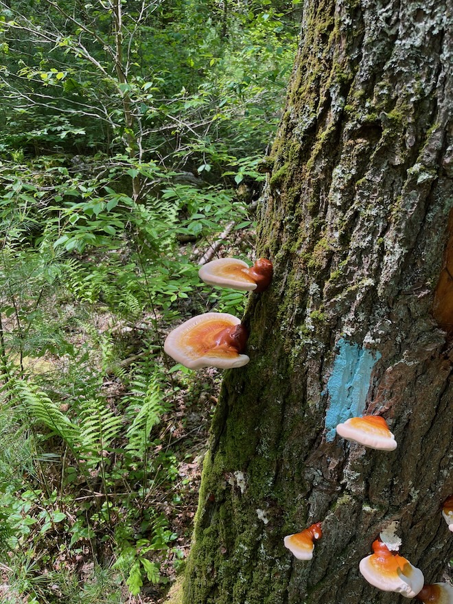
Blue blaze, caramel mushrooms
Below is a massive wall, probably built by white settlers without cement. Note the small opening for water-flow, at the bottom of the wall. Was the wall part of a berm, built to impound water for a mill? I marked its location with a yellow pin (it’s on the Nehantic Trail, just after that trail separates from the Pachaug Trail). A short side-trail takes you to the top of the wall, and allows you to see the back of the wall; I marked this side trail with a black hiker icon.

The Pachaug State Forest is almost 30,000 acres. Hunting is permitted, so you should wear “hunter orange” during the hunting season. Click here for the official map of the northern section of the Pachaug State Forest, where my route is. Click here for the official map of the southern section of the Pachaug State Forest.
The trails are maintained by the Connecticut Forest and Parks Association (CFPA). Their website has a “master map” of all the trails (unfortunately, it doesn’t show you where you are). Their website also has descriptions of the Pachaug, Nehantic, and Quinebaug Trails.
The above trail starts and ends in the northwestern part of Voluntown, Connecticut, but the western side of the route is in the next town, Griswold, Connecticut. Voluntown is a large town — about 40 square miles — with a small population — about 2,500 people. Etymology: parcels of land in Voluntown were given to those who had volunteered for the 1700 war against the Narragansetts. But many of these early settlers eventually gave up and moved out, perhaps because the land was low and swampy.
Robert Frost wrote,
There is a singer everyone has heard,
Loud, a mid-summer and a mid-wood bird,
Who makes the solid tree trunks sound again.
This is from a poem called The Oven Bird. In late May 2024, I heard countless Ovenbirds in Pachaug State Forest (I use an app called Merlin to identify bird-songs). I’m not surprised that the Ovenbird’s Conservation Status is “Least Concern.”
In late August, however, I didn’t hear a single Ovenbird; the woods were largely silent. The Ovenbird gets its name from its nest, “a domed structure placed on the ground, woven from vegetation, and containing a side entrance.”
I also heard thrushes — Wood Thrush and Hermit Thrush. When I walked north from my parking-spot, along Lowden Brook, I heard the Louisiana waterthrush. These three thrush species seem to have a “family resemblance” in appearance and in song.
Below is a quiet stretch of Lowden Brook (I marked the location with a purple pin).

The trail along Lowden Brook (a segment of the blue-blazed Pachaug Trail) is rocky and rough, though the brook is charming. If you want a smooth and easy trail, consider the Rhododendron Trail, which is handicap-accessible; the Rhododendron Trail is about .3 miles (3/10 miles), or .6 miles round-trip; it ends at a stream (Mt. Misery Brook) and a viewing platform. There are White Cedar trees along the trail. You can park at the start of the trail (I marked the approximate spot with a green pin). This parking-spot would also be suitable for hiking Mt. Misery.
Below is a map of the Rhododendron Trail and the trail to Mt. Misery; the whole route is about 2.25 miles.
One website says that Pachaug State Forest has “a rare Atlantic White Cedar swamp, July-blooming native rhododendron, and massive stands of mountain laurel that put on stunning displays in early June.”
Below is a 6-mile route in the southern section of the Pachaug State Forest. It’s flat, and it can be muddy after a rain. It has some NativeAmerican stone structures.
I parked on Tarkiln Hill Road, which is a very quiet road. You can probably park on Green Falls Road, about a half-mile west of Tarkiln Hill Road. Both Green Falls Road and Tarkiln Hill Road intersect with the Laurel Loop Trail. If you want a more formal parking area, there’s one on the northern edge of Green Fall Pond.
The eastern side of this route (as of the first route) is a segment of the Pachaug Trail, the western side is a segment of the Nehantic Trail, and the northern side is the Laurel Loop Trail, which connects the Pachaug and Nehantic Trails. The bottom of the route is Green Fall Pond, where the Pachaug and Nehantic Trails meet (or almost meet).
Below is a route that follows the Quinebaug Trail from Devil’s Den. I walked west and south to Hell Hollow Pond. This route ends on Hell Hollow Road, at the intersection of Hell Hollow Road and the Pachaug Trail. I put a blue pin at the overlook (the ledge, the flat rock). I put a black pin at a cellar-hole. You can turn this route into a loop by taking the Pachaug Trail along the east side of Hell Hollow Pond, then continuing northeast on a yellow-blazed connector trail. The whole circle is about 4 miles. On the east side of Hell Hollow Pond, I saw signs of beavers.

Devil’s Den, west side, looking east
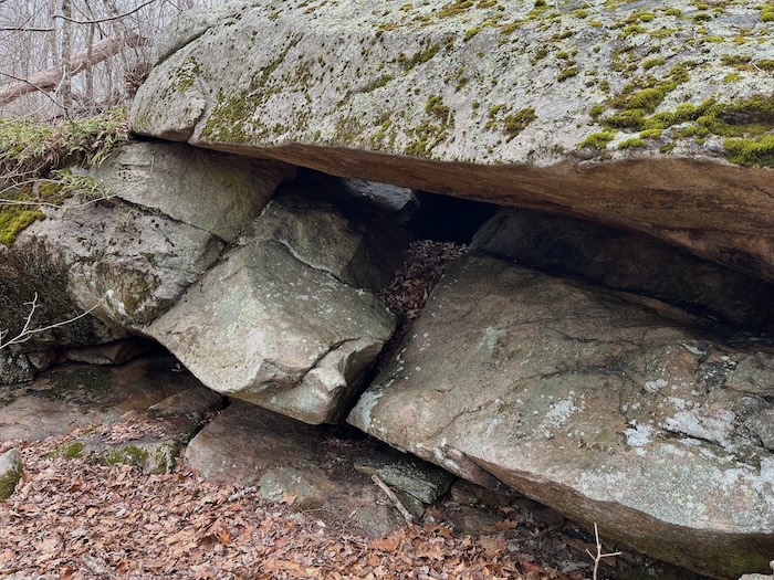
Devil’s Den, east side
More info about Devil’s Den here and here. I regard Devil’s Den as partly natural, partly native-made. It might be described as an overhanging boulder that forms a small cave.
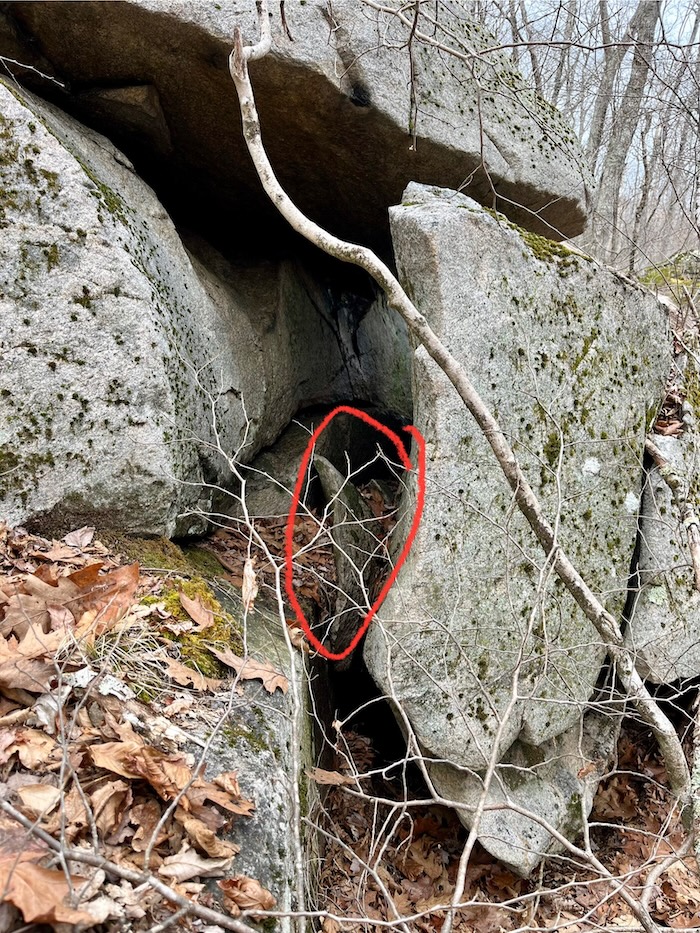
“What makes you think that Devil’s Den is ‘partly native-made.’ It looks completely natural to me.” In the picture below, I’ve circled a “propping rock.” This is a common sign of native work. Such a propping rock couldn’t squeeze into its present position without human help.
Now let’s look at the other side (the east side) of the same rocks. Here again we find a propping rock, which I’ve circled.
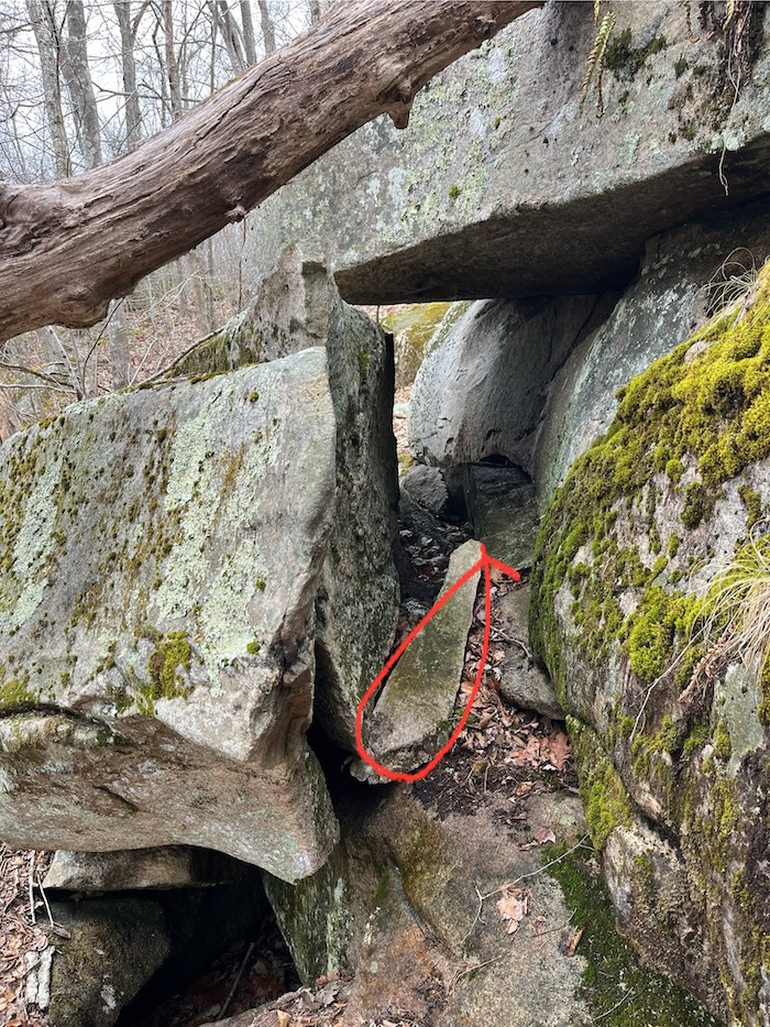
So I believe that Native Americans propped on both sides, to enlarge the “cave.”
If you leave Devil’s Den and continue west along Flat Rock Road, in 5-10 minutes you’ll reach a flat ledge on the south side of the trail (picture below). In the middle of the ledge is a boulder; the boulder is about 4 feet on each side, and has a flat top (as a result of being propped?). The ledge has a decent view, and it’s a good place for a picnic. “Flat Rock Road” probably gets its name from this ledge.

Ledge, overlook, flat rock
Below is an 8-9 mile route that I found in Ken Weber’s Walks and Rambles in Rhode Island. Most of it is in Connecticut.
Ken calls this route The Pachaug Trail; it’s actually a section of the 25-mile Pachaug Trail, which is one of Connecticut’s BlueBlazed trails. More precisely, the western half of my route is a section of the Pachaug Trail, while the eastern half is dirt roads and the Tippecansett Trail. I did the western half first, i.e., I did the loop clockwise, as Ken does it.
Ken calls this loop “a most enjoyable walk and a beautiful one.” I agree. The first half of the route has spectacular cliffs, ravines, and overhangs/caves. There’s NativeAmerican stone-work throughout the route, mostly stone piles. Ken says it’s a tiring and difficult walk, but I didn’t find it so, and AllTrails rates it “Moderate.”
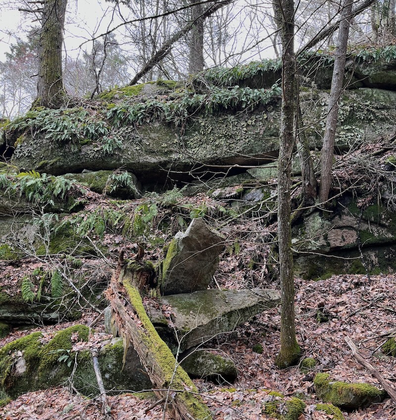
Below is a cliff festooned with ferns. At the base of the cliff are two stones that seem to have been propped by Native Americans. One points toward you, the other points to the right. The top stone, which points toward you, has the “diving board” character that I’ve seen elsewhere. These rocky scenes remind me of Chinese paintings.
There are numerous erratics along the trail; below is a photo of one of them; I marked its location with a brown pin. Is it propped? I’m not sure; I didn’t check all the erratics for propping, partly because I wanted to avoid ticks.

There’s a large parking lot at Beach Pond, on the north side of Route 165. But it’s reserved for boaters, so you may want to park on the south side of Route 165, near Beach Pond. If this isn’t possible, there’s a parking area further east, on the north side of Route 165 (this is where I parked).
The Pachaug Trail has blue blazes, while the Tippecansett Trail has yellow blazes. The Pachaug Trail is well-marked, but has few bridges, so you’ll be crossing streams on “stepping stones.”