Darwin had a keen interest in coral reefs, partly because he saw them on the voyage of the Beagle, partly because he read other naturalists who marveled at them and speculated about them, partly because he felt that he had discovered the secret of their structure, and partly because he thought they exemplified important geological principles — elevation, subsidence, Deep Time, etc.
Coral is made by tiny animals called polyps; polyps are related to jellyfish, and the hard structures they excrete are related to limestone. Aristotle said that astonishment is a very philosophical emotion, and Darwin expresses astonishment that tiny polyps build a structure that can hold back the mighty ocean, create a quiet lagoon inside, and even create low-lying islands of coral-rock and coral-sand.
| Almost every voyager who has crossed the Pacific [Darwin writes] has expressed his unbounded astonishment at the lagoon-islands [atolls], and has attempted some explanation.... The immensity of the ocean, the fury of the breakers, contrasted with the lowness of the land and the smoothness of the bright green water within the lagoon, can hardly be imagined without having been seen.1 |
Darwin divides coral reefs into three kinds: atoll reefs, barrier reefs, and fringing reefs. Atoll reefs often form a thin, ring-shaped island, which encloses a lagoon (see picture below).
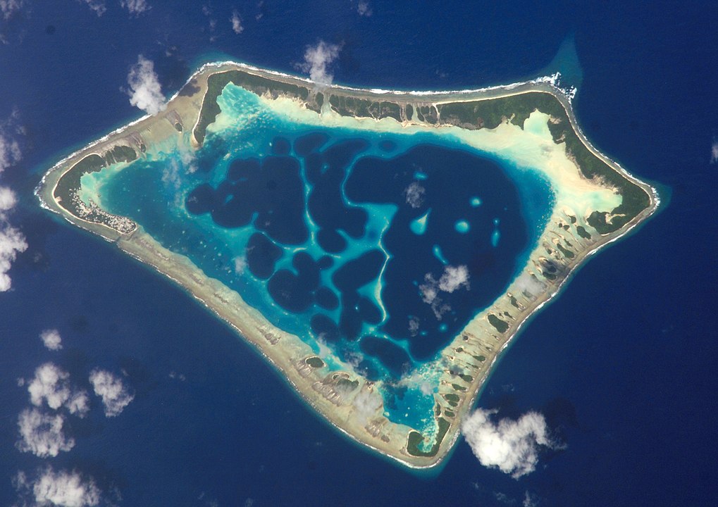
Barrier reefs “extend in straight lines in front of the shores of a continent or of a large island, or they encircle smaller islands; in both cases, being separated from the land by a broad and rather deep channel of water, analogous to the lagoon within an atoll.” Fringing reefs are found near the shore; they’re often separated from the shore by a shallow lagoon.
Coral reefs begin as fringing reefs. Coral usually grows in warm water that isn’t very deep (shallow enough to permit the sun to reach the coral, and perform photosynthesis). If the island fringed by the coral subsides under the sea, an atoll remains. The lagoon within is where the island once was, often a volcanic island. Darwin’s theory of reef-formation is based on the idea of subsidence. Since the Pacific region has had a lot of subsidence, atolls are common there (atolls are almost unknown in the Atlantic and the Caribbean).
In the case of a barrier reef, the land has sunk, but not completely disappeared. This partial sinking creates a broad and deep channel between land and reef. “We see in each barrier reef,” Darwin writes, “a proof that the land has there subsided, and in each atoll a monument over an island now lost.”
If the land under the reef subsides, why isn’t the reef submerged by deep water, and killed by deep water? The land usually subsides very slowly, and the coral grows fast enough to keep pace with the subsiding, and stay near the surface. One might even say that coral growth is a clock that tells the rate of subsidence. According to Wikipedia, “An island that is located where the ocean water temperatures are just sufficiently warm for upward reef growth to keep pace with the rate of subsidence is said to be at the Darwin Point.”
As atoll reefs indicate subsiding land, so fringing reefs indicate elevating land (without elevation, there would be neither island nor reef). As active volcanoes can create islands and fringing reefs, so dormant volcanoes can create atolls. So the study of coral reefs led Darwin to conclusions about the rising and falling of the surface of the earth.
| We must feel astonished [Darwin writes] at the vastness of the areas, which have suffered changes in level either downwards or upwards, within a period not geologically remote.... Throughout the spaces interspersed with atolls, where not a single peak of high land has been left above the level of the sea, the sinking must have been immense in amount. The sinking, moreover, whether continuous, or recurrent with intervals sufficiently long for the corals again to bring up their living edifices to the surface, must necessarily have been extremely slow.... We may thus, like unto a geologist who had lived his ten thousand years and kept a record of the passing changes, gain some insight into the great system by which the surface of this globe has been broken up, and land and water interchanged. |
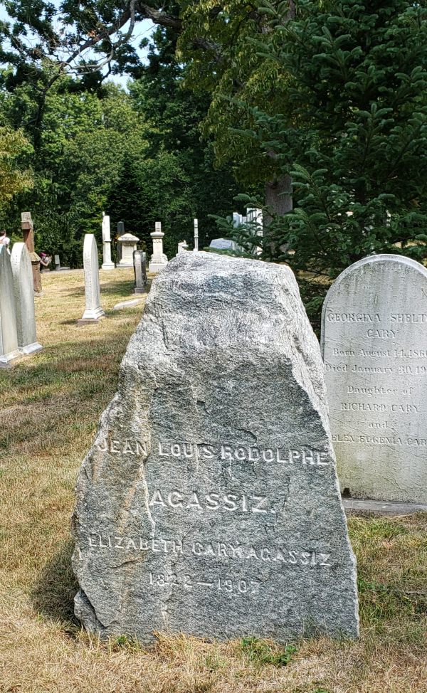
Louis Agassiz developed the theory of Ice Ages around 1840. Agassiz was born and raised in Switzerland, and studied with the celebrated naturalists Cuvier and Humboldt. Agassiz observed glaciers in Switzerland, and built a hut on a glacier to facilitate observation. He spent many years as a professor at Harvard. When he died in 1873, his tombstone was cut from a boulder near his Alpine hut, and transported to Mount Auburn Cemetery in Cambridge.
Most of Agassiz’s early works were written in French, while most of his later works are written in English. Though English wasn’t his native language, he writes excellent English prose. He often wrote for the lay reader. I recommend his Geological Sketches, which were originally published in Atlantic magazine.
When Agassiz was young, most geologists believed that the earth was once warmer than it is now. In the time of the dinosaurs, flora and fauna that we associate with the tropics extended beyond the tropics. Agassiz tried to persuade people that the earth was much colder at a relatively recent period, and that gigantic sheets of ice, a mile or two thick, moved from the polar regions into the temperate regions, and covered Massachusetts, Manhattan, etc. for most of the last 100,000 years. Agassiz found traces of an Ice Age in Switzerland, and later in Britain, North America, and South America. Agassiz’s IceAge theory is now widely accepted.
People who lived near glaciers had long noticed that glaciers expanded and retreated over time. When they retreated, they left behind rocks that were smoothed, rounded, polished, and marked by fine lines. Some people said that glaciers could transport erratic boulders, and deposit moraines (moraines are hills/ridges of dirt and gravel). So Agassiz’s theory of Ice Ages didn’t emerge ex nihilo, it emerged from a body of scholarly knowledge and folk wisdom. One might say that Agassiz didn’t create the theory of Ice Ages; rather, he extended it, and bolstered it with data.
One place where Agassiz gathered data was the Parallel Roads of Glen Roy, in Scotland.
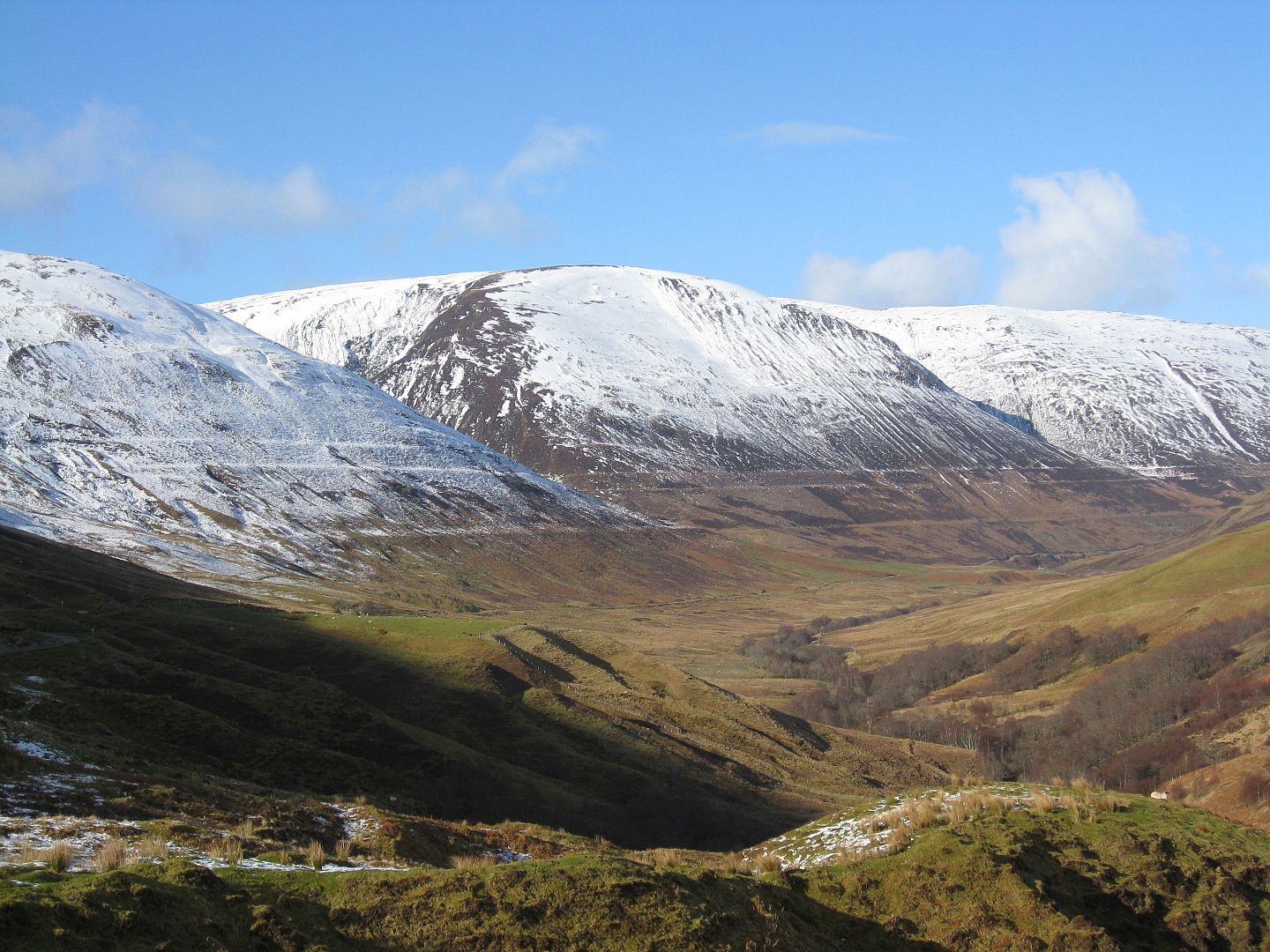
Note the parallel lines (“roads”) on the mountainside
Geologists knew that these “roads” weren’t man-made, and they suspected that the roads were made by the sea. Darwin published an essay on the Glen Roy roads in 1839. “This paper was a great failure,” Darwin later wrote, “and I am ashamed of it.... I attributed the parallel lines to the action of the sea; but I had to give up this view when Agassiz propounded his glacier-lake theory.”
Agassiz’s IceAge theory was slow to gain acceptance, as was Wegener’s theory of Continental Drift. One of those whom Agassiz converted was John Muir, who found evidence of glaciers in the Yosemite area. In a diary-entry, Muir wrote,
| Camp at the west end of Lake Tenaya. Arriving early, I took a walk on the glacier-polished pavements along the north shore, and climbed the magnificent mountain rock at the east end of the lake, now shining in the late afternoon light. Almost every yard of its surface shows the scoring and polishing action of a great glacier that enveloped it and swept heavily over its summit. |
Agassiz called Muir, “the first man I have ever found who has any adequate conception of glacial action.”
Below is a picture of Lembert Dome in Yosemite; Lembert Dome was also enveloped by a glacier, and left with a rounded, polished surface.
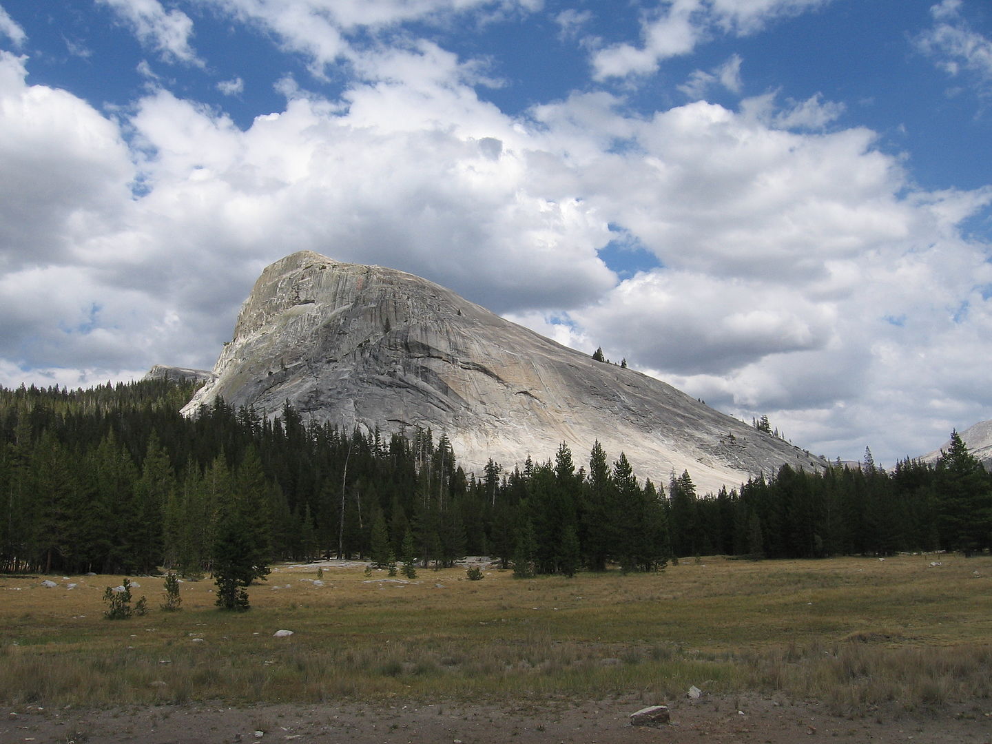
The shape of Lembert Dome is a shape that’s often created by glaciers; this shape is called a “roche moutonnée.”2 In the above picture, the glacier moved from right to left. Here’s a diagram of a roche moutonnée:

In my own walks in the Blue Hills, I noticed that it’s easy for a layman to find smoothed, rounded, lined rocks; these rocks are often at the top of hills. The lines are made by small stones under the ice sheet, stones that are pushed along the surface of a large rock as the ice sheet moves. One might compare these stones to a sculptor’s chisel, and the lines they leave to chisel marks. On Lembert Dome, we would expect to find the lines in the direction of movement, rather than perpendicular to it.
The ice sheet moved through Manhattan, stopped on Staten Island, and formed a ridge (“moraine”) halfway down Long Island. The moraine forms where the glacier pauses (stops advancing and starts melting). As the glacier retreats northward, it may pause again, and form another moraine, so moraines are sometimes found in a series. Glaciers have been compared to conveyor belts, carrying dirt and gravel to their edge, and dropping them. Below is a map of Long Island, showing two east-west moraines:

At the left side of this map, the moraine forms the high ground of Greenwood Cemetery, Park Slope, Forest Hills, etc. Since the moraine wasn’t flat, it wasn’t ideal for building, so it was left undeveloped, and later was used for cemeteries, parks, golf courses, etc.
On the above map, the southern half of Long Island is labelled “Outwash Plain.” This is where the meltwater (water from the melting glacier) carries sand and other small particles, and drops them. So the southern half of Long Island is generally flat, its beaches sandy. The northern half of Long Island is more hilly, its beaches more rocky. Where the glacier goes, it creates hills, and drops rocks and boulders. Where the glacier doesn’t reach (the Outwash Plain), you find sandy, flat ground.
Below is a satellite map of Long Island. Note that the northern half of the island is greener. The southern half, being flat, was better suited for building, and was more intensively developed, hence more trees were felled. And since the southern half is sandier, it may have been less wooded to begin with.
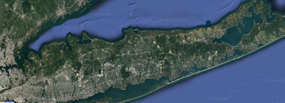
What’s true of Long Island is also true of Nantucket Island: the glacier came halfway down, paused, dropped dirt and gravel, then began retreating. So the southern half of Nantucket is an outwash plain, flat and sandy, while the northern half is more hilly and rocky. Some of the beaches on Nantucket’s north shore have a high bluff, but the south-shore beaches are flatter, less “bluffy.” Below is a terrain map of Nantucket, showing hilly ground in the north, a flat plain in the south.3
The grid lines in the bottom right are a cranberry bog; cranberry bogs are found on flat ground. Outwash plains seem to have few streams, perhaps because rain-water sinks rapidly into the sandy soil, perhaps because the flat terrain doesn’t allow water to flow.
Below is a photo of “Nantucket Serengeti.”
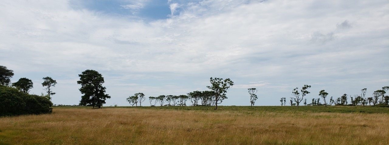
Like the cranberry bog, Nantucket Serengeti is found on the flat Outwash Plain. (Nantucket Serengeti is along Milestone Road, just southwest of the cranberry bog.)
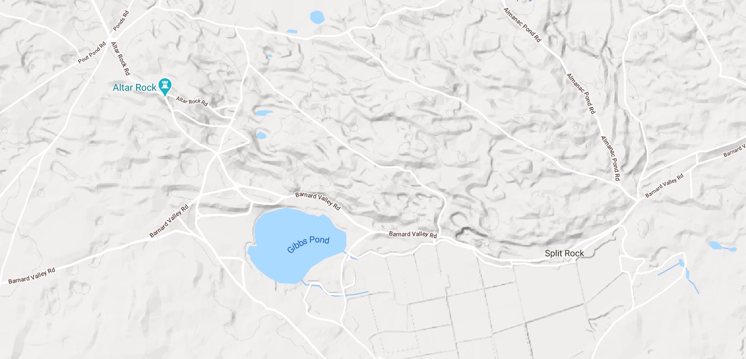
Below is a map of Nantucket ponds.
You’ll notice that the ponds are parallel to each other. They were all formed by meltwater flowing south (southwest) from the glacier, through the Outwash Plain. The ponds began as streams flowing to the sea, then their mouths were blocked by shifting sand, and they became ponds.
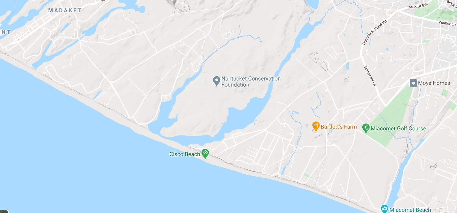
One might compare these Nantucket ponds to the parallel ponds in East Falmouth:
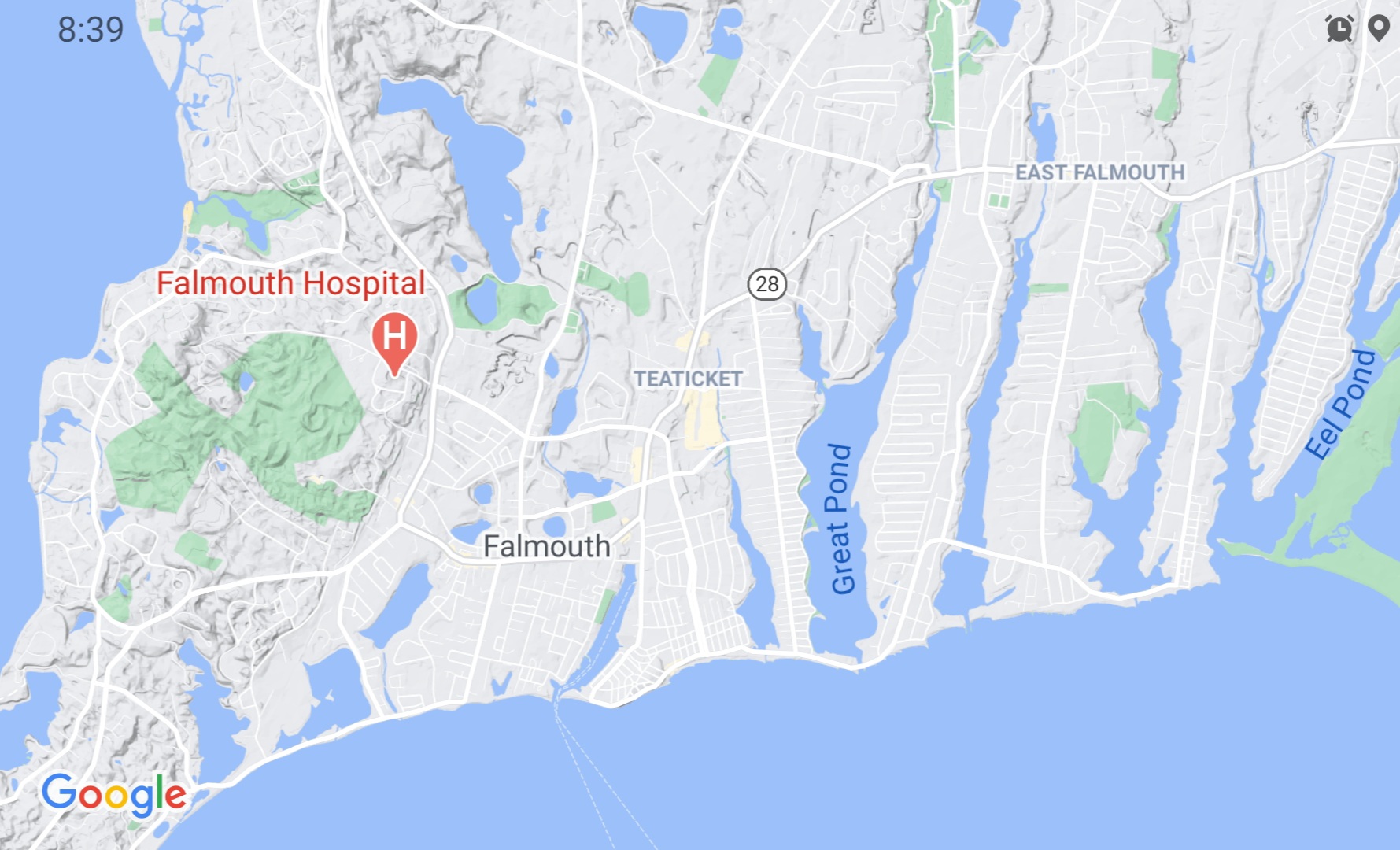
Like the Nantucket ponds, the Falmouth ponds were part of an Outwash Plain, they were probably streams whose mouths were blocked by sand, sand that was thrown up by the ocean during a storm. But now the Falmouth ponds are connected to the sea by human engineering.
East Falmouth is part of an Outwash Plain that extends to Chatham. This Outwash Plain, like the ones on Nantucket and Long Island, lies south of a moraine. Cape Cod has a northern moraine and a western moraine; these two moraines were created by two different lobes of the ice sheet.3B
On the map below, I drew a red line to indicate Cape Cod’s northern moraine, south of which is the Outwash Plain. I drew a purple line to indicate the western moraine, which extends to the Elizabeth Islands. The western moraine has a 9-mile moraine trail.

Doubtless there are many examples of ponds/lakes in a series (parallel to each other). Consider, for example, New York’s Finger Lakes, which were created by glacial action.
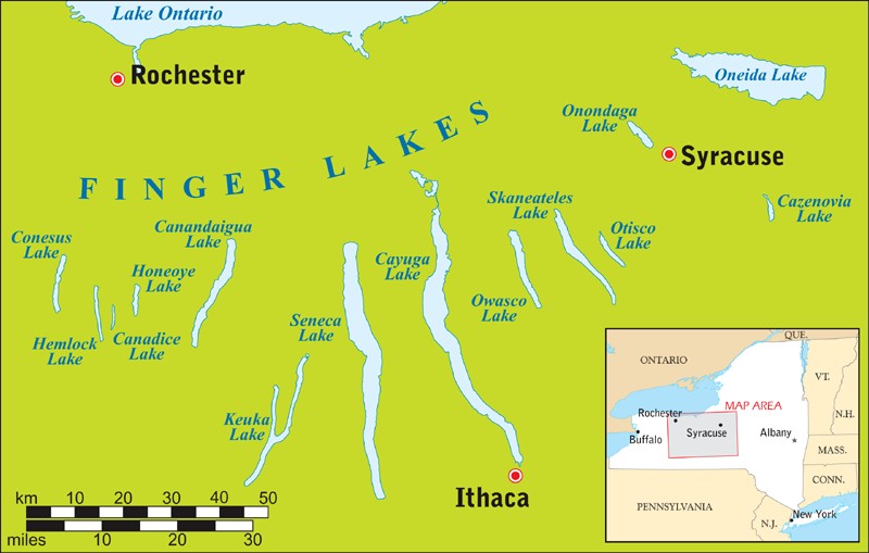
Like the Nantucket ponds and the Falmouth ponds, the Finger Lakes were once streams. The glacier deposited a moraine that blocked these “Finger Streams,” changing them into Finger Lakes. Sometimes a river is strong enough to blast through such a moraine/dam. The Hudson River, for example, blasted through the moraine that runs through Staten Island and Long Island. As the New York Times describes it,
| Some 13,000 years ago, a large accumulation of icy water from melting glaciers was suddenly unleashed upstate. A towering wave of destruction crashed down through the Hudson gorge and proceeded to smash the southern end of the local moraine to smithereens. “It was biblical”.... The wave created the Narrows, which now connects the Atlantic Ocean to one of the world’s largest natural harbors. |
This shows how many of the land forms that we see around us were created in the (relatively) recent past. One might say that Lyell developed the idea of Deep Time, and then Agassiz developed the idea of Shallow Time; Agassiz’s IceAge theory says that many of the land-forms that we see around us were created relatively recently.
If New York Harbor was formed just 13,000 years ago, if so many changes have taken place in the last 13,000 years, imagine how many changes have taken place in the last 100,000 years, or the last 100 million years! As Darwin put it, “Daily it is forced home on the mind of the geologist, that nothing, not even the wind that blows, is so unstable as the level of the crust of this earth.”
And if you experience an earthquake, as Darwin did in Chile, then the instability of the earth is actually felt.
| It came on suddenly [Darwin wrote], and lasted two minutes, but the time appeared much longer. The rocking of the ground was very sensible.... There was no difficulty in standing upright, but the motion made me almost giddy: it was... like that felt by a person skating over thin ice, which bends under the weight of his body. A bad earthquake at once destroys our oldest associations: the earth, the very emblem of solidity, has moved beneath our feet like a thin crust over a fluid — one second of time has created in the mind a strange idea of insecurity, which hours of reflection would not have produced. |
But if we never experience an earthquake, and we never study geology, the earth appears solid and stable, just as, if we don’t study astronomy, we would never know that the earth is spinning rapidly, and rapidly revolving around the sun. Our senses sometimes deceive us.
One might suppose that, in the Northern Hemisphere, the glaciers always advanced southward, and retreated northward. In fact, the glaciers in the Alps (and other mountain ranges) sometimes came down from the heights and advanced northwards, later retreating southwards.
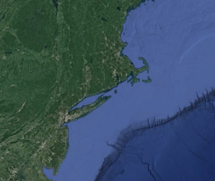
One might suppose that the glaciers would need to cross the sea to reach Long Island and Nantucket Island. In fact, these islands were part of the mainland at that time; glaciers don’t move across seas. As Agassiz said,
| Nantucket, Martha’s Vineyard, and Long Island made part of the mainland.... The line of shallow soundings along the whole coast of the United States marks the former extent of [the land]. The ocean has gradually eaten its way into [the land], and given its present outlines to the continent. |
Below is an image from Google Earth showing “the line of shallow soundings,” also known as the Continental Shelf.
Just as Lembert Dome was smoothed and polished by a glacier, so too rocks on Manhattan were smoothed and polished by a glacier. Below is a picture of Umpire Rock in Central Park.
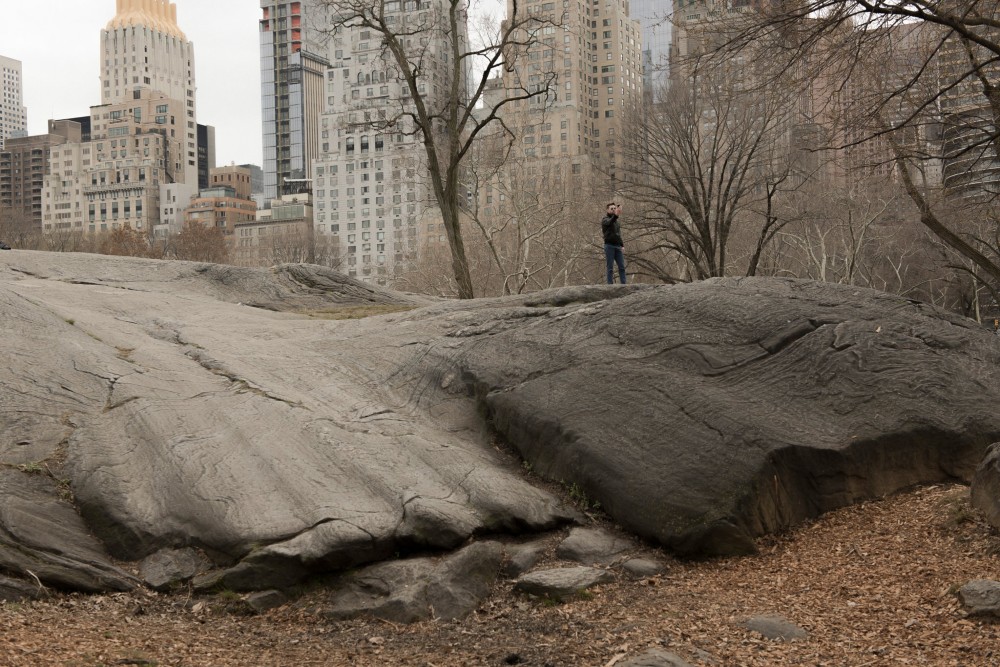
The New York Times says that Umpire Rock’s “distinctive grooves were formed by glacial ice and rubble.”
Agassiz argued that erratic boulders were often transported by glaciers. Erratic boulders are boulders that have wandered far from their place of origin. The term “erratic” comes from the Latin errare, to wander. An erratic made of granite might be sitting in a region of sandstone. If the region of sandstone is 200 miles south of a region of granite, a geologist might presume that the erratic was carried from that granite region to the sandstone region. Erratics haven’t been smoothed or lined by the glacier because they aren’t crushed under the glacier, they’re riding on top of the glacier; they’re angular rather than rounded. They’re often found on the tops of hills/ridges.
Before Agassiz, the prevailing explanation of erratics was that they were carried by icebergs. Lyell championed the iceberg theory, and Darwin was firmly attached to it. When Darwin found erratics in Argentina, he said, “It is, I believe, quite impossible to explain the transportal of these gigantic masses of rock so many miles from their parent-source, on any theory except by that of floating icebergs.”
Agassiz didn’t completely reject the iceberg theory. He said that both icebergs and glaciers transported boulders. Truth was a combination of the glacier theory and the iceberg theory. And the same was true of the earlier dispute between Neptunists (who argued that rocks were formed by water) and Vulcanists (who argued that rocks were formed by heat/fire/volcanoes): truth was a combination of Neptune and Vulcan, rocks were formed by both water and heat. And the same was true of the dispute between Catastrophists (who argued that the earth was formed by catastrophic events) and Uniformitarians (who argued that the earth was formed by gradual change over long periods of time): truth was a combination of both, the earth was formed by dramatic catastrophes (such as asteroids striking the earth), and by a long series of small changes.
Is this pattern found in the humanities, too? Is truth often a synthesis, a synthesis of thesis and antithesis, as Hegel argued? Jung said that posterity would take elements of his system, and elements of Freud’s; in other words, posterity would synthesize Jung’s system and Freud’s.
Darwin’s Autobiography is concise, clear, and profound, a good summary of his life and work. One of the central facts of his life was the disintegration of his Christian faith, and one of the central facts of his time was the disintegration of faith among his English contemporaries. Darwin lists the reasons why he abandoned Christianity:
- The Old Testament doesn’t seem to be divinely-inspired (“From its manifestly false history of the world, with the Tower of Babel, the rainbow as a sign, etc., etc., and from its attributing to God the feelings of a revengeful tyrant, [the Old Testament] was no more to be trusted than the sacred books of the Hindus, or the beliefs of any barbarian.”)
- The miracles in the New Testament aren’t credible (“The more we know of the fixed laws of nature the more incredible do miracles become... the clearest evidence would be requisite to make any sane man believe in the miracles by which Christianity is supported... the men at that time were ignorant and credulous to a degree almost incomprehensible by us.”)
- The texts that make up the New Testament are suspect, they aren’t authentic, eyewitness accounts (“The Gospels cannot be proved to have been written simultaneously with the events... they differ in many important details.”)
- Christianity isn’t unique or special, it’s just another religion (“The fact that many false religions have spread over large portions of the earth like wild-fire had some weight with me.”)
- The discovery of natural selection has overturned the argument from design — the argument that the world shows signs of having been designed by an intelligent being (“the old argument of design in nature, as given by Paley, which formerly seemed to me so conclusive, fails, now that the law of natural selection has been discovered. We can no longer argue that, for instance, the beautiful hinge of a bivalve shell must have been made by an intelligent being.”)
- So many innocent people and animals suffer so much! If the world were created and governed by an omnipotent, omniscient, and benevolent being, would there be so much undeserved suffering? (“This very old argument from the existence of suffering against the existence of an intelligent first cause seems to me a strong one.”)
- Most modern believers speak of an inner feeling, an inner conviction, but this argument can be used to support any religion (“At the present day the most usual argument for the existence of an intelligent God is drawn from the deep inward conviction and feelings which are experienced by most persons. But it cannot be doubted that Hindus, Muslims and others might argue in the same manner and with equal force in favor of the existence of one God, or of many Gods, or as with the Buddhists of no God.”)
- Belief in God is widespread not because it’s plausible, but because it’s planted in our minds at a young age, and we grow up with it (“Nor must we overlook the probability of the constant inculcation in a belief in God on the minds of children producing so strong and perhaps an inherited effect on their brains not yet fully developed, that it would be as difficult for them to throw off their belief in God, as for a monkey to throw off its instinctive fear and hatred of a snake”)
- Christianity promises damnation to unbelievers, so we should hope it isn’t true (“I can indeed hardly see how anyone ought to wish Christianity to be true; for if so the plain language of the text seems to show that the men who do not believe, and this would include my Father, Brother and almost all my best friends, will be everlastingly punished.”)
Darwin has a rational bent, and he took a rational approach to religion. Jung took a different approach to religion. Jung defended religion as psychologically true. Jung argued, for example, that the Son of God is a genuine archetype — a psychological truth. So for Jung, the notion that Jesus was the son of God isn’t an absurdity.4
Darwin had three weaknesses, which were characteristic of his time and place: he didn’t appreciate the unconscious, he didn’t appreciate Eastern wisdom, and he didn’t grasp the wholeness of the world, the occult connectedness of the world. These three weaknesses make him more popular with today’s scientists, because they find a rational approach congenial, they don’t want to go below the surface.
Though Darwin’s approach to religion can be called rational, his approach to ethics shows a respect for non-rational factors, a respect for human nature as a whole, a respect for feeling/impulse. He says that a person who has cast off religion
| can have for his rule of life, as far as I can see, only to follow those impulses and instincts which are the strongest or which seem to him the best ones. A dog acts in this manner, but he does so blindly. A man, on the other hand, looks forwards and backwards, and compares his various feelings, desires and recollections. |
Many of Darwin’s contemporaries abandoned Christianity. But people who grew up with Christianity, as Darwin did, were usually attached to it, and abandoned it with regret; it was difficult for them to make sense of the world without Christianity. “I was very unwilling to give up my belief,” Darwin writes. “I can well remember often and often inventing day-dreams of old letters between distinguished Romans and manuscripts being discovered at Pompeii or elsewhere which confirmed in the most striking manner all that was written in the Gospels.” Darwin wanted to believe, but couldn’t. One might say that he needed time to grow accustomed to a world without Christianity, he needed time to feel at home in a godless world.
Darwin is optimistic about the future of mankind: “Man in the distant future will be a far more perfect creature than he now is.” This is Victorian optimism, the optimism that died in the trenches of World War I. Because of this optimism, Darwin can’t bear the thought that someday the sun will burn out, and life will be extinguished. I find this thought more tolerable, perhaps because I’m less optimistic than Darwin, perhaps because I’m concerned with a Zennish awareness of the present rather than a gradual advance to perfection. If everything in the universe is changing, how can we expect life on earth to be permanent?
The cloud-capp’d towers, the gorgeous palaces,
The solemn temples, the great globe itself,
shall dissolve [and]
Leave not a rack behind.
© L. James Hammond 2020
feedback
visit Phlit home page
become a patron via Patreon
make a donation via PayPal
| Footnotes | |
| 1. | The Voyage of the Beagle, Ch. 20. Darwin also devoted a book to coral reefs. Darwin’s reef theory is probably derived from Lyell, who said that the Pacific had experienced much subsidence, and that atolls were probably volcanic craters. back |
| 2. | The term “roche moutonnée” might be translated “sheep rock.” One might suppose that it refers to the shape of a sheep. Actually, it refers to the mutton-fat used to smooth and shape wigs. So perhaps we should translate roche moutonnée as “smoothed rock.”
A drumlin is a hill made of glacial till (sand, gravel, rocks, etc.). Drumlins are often elongated, loaf-shaped, and they’re often oriented in the direction of the ice flow. Drumlins often have a high end and a low end. The high end (or stoss) faces into the ice flow, the low end (or lee) faces away. Thus, the shape of a drumlin is the opposite of the shape of a roche moutonnée, which has its low side facing into the ice. Perhaps their shapes are opposite because they were formed by opposite processes: roche moutonnée are formed by the glacier carving rock, drumlins are formed by the glacier depositing material. Drumlins are sometimes “drowned” when the land around them is submerged by the sea. Charlton Ogburn says that some of the islands in Boston Harbor are drumlins.
When Thoreau was in Maine, he saw a series of hills that had the same shape. They were probably roche moutonnée. Thoreau writes, “Being struck with the perfect parallelism of these singular rock hills, however much one might be in advance of another, I took out my compass and found that they lay northwest and southeast.... rising gradually from the northwest to the height of about eighty feet, but steep on the southeast end.... There was a remarkable series of these great rock-waves... breakers, as it were.” In this part of Maine, the glacier was probably moving from northwest to southeast. back |
| 3. | When we say, “the glacier came halfway down Nantucket and stopped,” it suggests that the island existed before the glacier. In fact, the glacier created the island.
Golf developed in Scotland, where the glacier had created a hilly terrain. Golf became associated with hilly terrain, so if a golf course is built on flat ground, bulldozers are called in to make hills, to simulate glacial action. Below is a terrain map of southern Rhode Island. You’ll notice a moraine (hilly land) north of Route 1, and flat land south of Route 1.
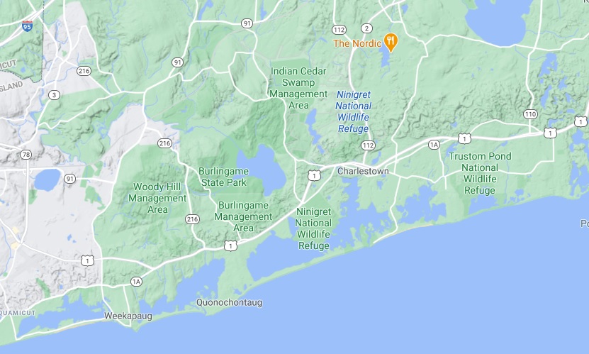
The flat land is an Outwash Plain. A sign at Ninigret Refuge says that the Plain was good for farming, though the soil may have been somewhat sandy. Later Ninigret Refuge became an airport, a training area for Navy pilots; the flat terrain was well suited for an airport. So southern Rhode Island resembles Long Island, Nantucket, and Cape Cod; in all three places, the southern section has Outwash Plain, and north of the Plain is hilly ground (glacial moraine). back |
| 3B. | See Charlton Ogburn’s The Winter Beach, Ch. 4, “Cape Cod,” p. 88. Ogburn writes about geology in a way that the layman can understand, perhaps because he himself is a layman.
Ogburn notes that the eastern edge of Cape Cod, like the eastern edge of Nantucket, is being eaten away by the ocean, and is becoming flatter. “The grim truth,” Ogburn writes, “is that the face of the cliff with which the Cape fronts the ocean is receding at a rate of three feet a year.... When it stood much farther out at sea it must have stood much higher too.” The Cape’s Nauset lighthouse was rebuilt further from the ocean, while Nantucket’s Sankaty Head Light was moved westward. The term “head” or “headland” implies cliff. Ogburn says that Sankaty Head resembles the cliff on the eastern edge of Cape Cod; he says that the Sankaty cliff is “a sheer 85 feet.” I suspect that it’s lower now than when Ogburn visited Nantucket in the 1960s. Ogburn says that the CapeCod cliff is 175 feet in one place. Is it still? Wikipedia says that capes are “prone to natural forms of erosion.... This results in capes having a relatively short geological lifespan.”
As the cliff is eroded, some of the material is swept along and becomes a point. Ogburn says that Race Point, at the northern end of Cape Cod, is “land built out into the sea within the period of human history.” back |
| 4. | Freud’s approach to religion is more rational than Jung’s, and closer to Darwin’s. In general, Freud seems more impressed with Darwin than Jung was. People with a rational bent, like Freud and Darwin, usually take a negative view of religion. back |